IMAGES TAKEN NEAR TO
Pen Y Wern, BANGOR, LL57 4TS
Introduction
This page details the photographs taken nearby to Pen Y Wern, LL57 4TS by members of the Geograph project.
The Geograph project started in 2005 with the aim of publishing, organising and preserving representative images for every square kilometre of Great Britain, Ireland and the Isle of Man.

There are currently over 7.5m images from over14,400 individuals and you can help contribute to the project by visiting https://www.geograph.org.uk
Image Map
Images are licensed for reuse under creativecommons.org/licenses/by-sa/2.0
Notes
- Clicking on the map will re-center to the selected point.
- The higher the marker number, the further away the image location is from the centre of the postcode.
Image Listing (44 Images Found)
Images are licensed for reuse under creativecommons.org/licenses/by-sa/2.0
Image
Details
Distance
3
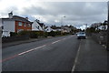
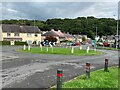
Coed Mawr Road
An important north-south link on the western outskirts of Bangor. This road did not exist until the 1960s.
Image: © Eric Jones
Taken: 9 Sep 2006
0.09 miles
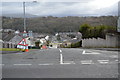
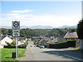
6
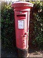
King George V pillar box on Penrhos Road, Bangor
LL57 269
Image: © Meirion
Taken: 4 Oct 2019
0.10 miles
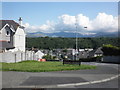
7
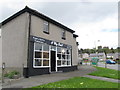
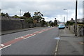
Punning Chip Shop name
Like hairdressers, chip shop names are often weak puns. This one used to be called The Plaice to Be.
This is one of four shops along Ffordd Coed Mawr, serving what I believe to be a post-war council estate.
Image: © SK53
Taken: 7 May 2015
0.12 miles