IMAGES TAKEN NEAR TO
Maes Ogwen, BANGOR, LL57 4NH
Introduction
This page details the photographs taken nearby to Maes Ogwen, LL57 4NH by members of the Geograph project.
The Geograph project started in 2005 with the aim of publishing, organising and preserving representative images for every square kilometre of Great Britain, Ireland and the Isle of Man.

There are currently over 7.5m images from over14,400 individuals and you can help contribute to the project by visiting https://www.geograph.org.uk
Image Map
Images are licensed for reuse under creativecommons.org/licenses/by-sa/2.0
Notes
- Clicking on the map will re-center to the selected point.
- The higher the marker number, the further away the image location is from the centre of the postcode.
Image Listing (50 Images Found)
Images are licensed for reuse under creativecommons.org/licenses/by-sa/2.0
Image
Details
Distance


4
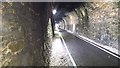
Multi-user tunnel
The new section of Lôn Las Ogwen runs through this tunnel. Heading towards the camera is a boy on a skateboard, to illustrate the multi-user aspect.
Image: © David Medcalf
Taken: 21 Jun 2017
0.07 miles
5

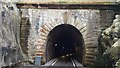
Tregarth tunnel
The tunnel passes right under part of the village and is now used as a cycle and pedestrian way. Formerly the route of the Bangor to Bethesda branch line.
Image: © Gordon Hatton
Taken: 24 Sep 2020
0.08 miles
6
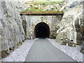
Dinas Tunnel, Tregarth
The Tregarth-side portal of Dinas Tunnel which you can now walk/cycle through.
Image: © Meirion
Taken: 17 May 2017
0.09 miles
7
Fine stonework
At the entrance to the old railway tunnel.
Image: © David Medcalf
Taken: 21 Jun 2017
0.09 miles
8

Deep cutting and tunnel at Tregarth
Now a cycle and pedestrian route, this was once the branch line to Bethesda from Bangor.
Image: © Gordon Hatton
Taken: 24 Sep 2020
0.10 miles
9

The old cutting restored to new life
The new section of Lôn Las Ogwen multi-user path follows the old railway line.
Image: © David Medcalf
Taken: 21 Jun 2017
0.11 miles
10

Cutting and bridge
A wonderful construction in blue engineering brick carries a minor road over the former Llanberis branch railway line, now converted into a superb leisure path. Tensile netting prevents falling rocks from reaching the track, a hazard that is particular to the northeast side of the cutting due to the intersection of the regional cleavage with the excavation. The sound-effects of the steam trains pounding up this inclined route must have been wonderful.
Image: © Jonathan Wilkins
Taken: 30 Jul 2020
0.12 miles