IMAGES TAKEN NEAR TO
Llandygai Village, BANGOR, LL57 4HU
Introduction
This page details the photographs taken nearby to Llandygai Village, LL57 4HU by members of the Geograph project.
The Geograph project started in 2005 with the aim of publishing, organising and preserving representative images for every square kilometre of Great Britain, Ireland and the Isle of Man.

There are currently over 7.5m images from over14,400 individuals and you can help contribute to the project by visiting https://www.geograph.org.uk
Image Map
Images are licensed for reuse under creativecommons.org/licenses/by-sa/2.0
Notes
- Clicking on the map will re-center to the selected point.
- The higher the marker number, the further away the image location is from the centre of the postcode.
Image Listing (87 Images Found)
Images are licensed for reuse under creativecommons.org/licenses/by-sa/2.0
Image
Details
Distance
1
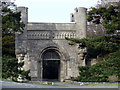
Penrhyn Castle Grand Lodge Gate
This is the Grand Lodge gate for Penrhyn Castle which was built for the wealthy Pennant family on the profits of Welsh slate and Jamaican sugar, Penrhyn Castle is an extravagant example of early 19th century neo-Norman architecture.
Image: © Nigel Williams
Taken: 22 Jan 2006
0.04 miles
4
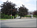
Entrance to the estate village of Llandygai
Llandygai developed as a model village housing the estate workers of the Penrhyn Estate.
Image: © Eric Jones
Taken: 21 May 2008
0.06 miles
5
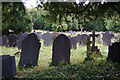
Churchyard of St Tegai, Llandygai
There seem to be different options for spelling, including the village which is also seen locally as Llandegai.
Image: © Bill Boaden
Taken: 18 Sep 2015
0.06 miles
6
Old Milestone by the former A55, Llandegai Road, Llandygai Parish
By the UC road (was A55), in parish of Llandygai (Gwynedd District), Llandygai, South East of junction with the A5 roundabout, set into stone wall, North East side of road.
Inscription reads:- : {pointing hand} TO BANGOR 1½ / TO ABER 8½ / TO CONWAY 12½ {pointing hand} :
Surveyed
Milestone Society National ID: CAE_BGCW02A
Image: © Christopher Leather
Taken: 27 Jul 2024
0.07 miles
7

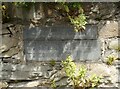
Old Milestone by the former A55, Llandegai Road, Llandygai Parish
By the UC road (was A55), in parish of Llandygai (Gwynedd District), Llandygai, South East of junction with the A5 roundabout, set into stone wall, North East side of road.
Inscription reads:- : {pointing hand} TO BANGOR 1½ / TO ABER 8½ / TO CONWAY 12½ {pointing hand} :
Surveyed
Milestone Society National ID: CAE_BGCW02A
Image: © Milestone Society
Taken: 1 Jan 1900
0.07 miles
8
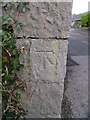
1GL benchmark on wall at village entrance, Llandegai
This 1GL benchmark located on wall at the entrance to Llandegai village was used during the Ordnance Survey's First Primary Levelling on the line between Warrington and Pembroke Docks, between September 1851 and July 1852. This mark was mark No.274 along this levelling line. The Ordnance Survey database shows that this mark was last inspected in 1942 and is 44.0850m above the Newlyn datum.
Image: © Meirion
Taken: 11 Feb 2011
0.07 miles

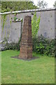
10
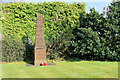
War Memorial, Llandygai
Obelisk sited on the grass outside the entrance lodge to Penrhyn Castle.
Image: © David Dixon
Taken: 29 Mar 2022
0.07 miles