IMAGES TAKEN NEAR TO
Caerhun, BANGOR, LL57 4DT
Introduction
This page details the photographs taken nearby to LL57 4DT by members of the Geograph project.
The Geograph project started in 2005 with the aim of publishing, organising and preserving representative images for every square kilometre of Great Britain, Ireland and the Isle of Man.

There are currently over 7.5m images from over14,400 individuals and you can help contribute to the project by visiting https://www.geograph.org.uk
Image Map
Images are licensed for reuse under creativecommons.org/licenses/by-sa/2.0
Notes
- Clicking on the map will re-center to the selected point.
- The higher the marker number, the further away the image location is from the centre of the postcode.
Image Listing (12 Images Found)
Images are licensed for reuse under creativecommons.org/licenses/by-sa/2.0
Image
Details
Distance
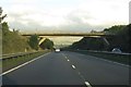
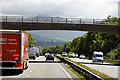
2
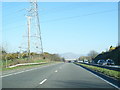
A typical road bridge over the A55, near Bangor
An Eastbound view, showing the snow-covered mountains of Snowdonia ahead. This section of the A55 makes up the Bangor Bypass and opened in 1983.
Image: © Oliver Mills
Taken: 5 Jan 2022
0.08 miles
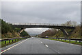
3
The A55 runs under a bridge near Caerhun
Image: © Steve Daniels
Taken: 27 Aug 2015
0.08 miles
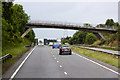
4
Bridge over the North Wales Expressway near to Glasinfryn
Image: © David Dixon
Taken: 21 Jun 2018
0.08 miles
5
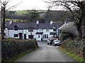
Cottages outside Caerhun
Cottages outside Caerhun on the road to Minffordd on a very sharp bend
Image: © Nigel Williams
Taken: 22 Jan 2006
0.11 miles
6
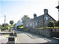
Roadside Cottages on the Outskirts of Caerhun
These rural cottages are within a hundred metres of the busy A5(T) Expressway
Image: © Eric Jones
Taken: 9 Sep 2006
0.11 miles
8
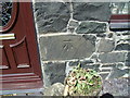
Benchmark at Four Alls, Pant-caerhun
This benchmark is located on SE face of Four Alls in Pant-caerhun & it is shown in the current Ordnance Survey database at a height of 85.7890m above the Newlyn datum.
Image: © Meirion
Taken: 2 May 2011
0.13 miles
9
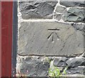
Ordnance Survey Cut Mark
This OS cut mark can be found on the front of Four Alls Pant Caerhun. It marks a point 85.789m above mean sea level.
Image: © Adrian Dust
Taken: 23 Jun 2016
0.13 miles
10
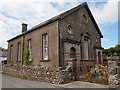
Caerhun Methodist Chapel
A grade II listed building, rebuilt in 1895. Currently not in use.
Image: © Chris Andrews
Taken: 11 Jun 2017
0.13 miles