IMAGES TAKEN NEAR TO
Arafon, BANGOR, LL57 4BX
Introduction
This page details the photographs taken nearby to Arafon, LL57 4BX by members of the Geograph project.
The Geograph project started in 2005 with the aim of publishing, organising and preserving representative images for every square kilometre of Great Britain, Ireland and the Isle of Man.

There are currently over 7.5m images from over14,400 individuals and you can help contribute to the project by visiting https://www.geograph.org.uk
Image Map
Images are licensed for reuse under creativecommons.org/licenses/by-sa/2.0
Notes
- Clicking on the map will re-center to the selected point.
- The higher the marker number, the further away the image location is from the centre of the postcode.
Image Listing (18 Images Found)
Images are licensed for reuse under creativecommons.org/licenses/by-sa/2.0
Image
Details
Distance
2
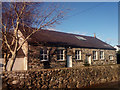
The memorial hall, Mynydd Llandegai
Neuadd Goffa
See also: Image
Image: © Meirion
Taken: 20 Jan 2020
0.05 miles
3
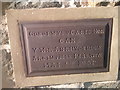
A slate plaque on the memorial hall, Mynydd Llandegai
See also: Image
Image: © Meirion
Taken: 20 Jan 2020
0.05 miles
4
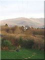
Fell View
View from Tan-y-Bwlch to the roof tops of Mynydd Llandegai and the fells of the Snowndonia National Park beyond.
Image: © J Scott
Taken: 12 Dec 2004
0.09 miles
5
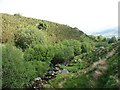
Afon Caledffrwd below Pont Caledffrwd bridge
Image: © Eric Jones
Taken: 31 May 2008
0.14 miles
8
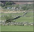
Patrymau caeau ar Fynydd Llandygai / Field patterns on Mynydd Llandygai
Image: © Ceri Thomas
Taken: 21 Apr 2019
0.17 miles
9

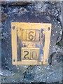
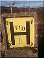
Benchmark on boulder, Mynydd Llandegai
For more details see: https://www.bench-marks.org.uk/bm114242
Image: © Meirion
Taken: 12 Jul 2020
0.18 miles
10
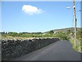
View West along the Mynydd Llandegai road from the Gefnan junction
Image: © Eric Jones
Taken: 31 May 2008
0.18 miles