IMAGES TAKEN NEAR TO
Tregarth, BANGOR, LL57 4BD
Introduction
This page details the photographs taken nearby to LL57 4BD by members of the Geograph project.
The Geograph project started in 2005 with the aim of publishing, organising and preserving representative images for every square kilometre of Great Britain, Ireland and the Isle of Man.

There are currently over 7.5m images from over14,400 individuals and you can help contribute to the project by visiting https://www.geograph.org.uk
Image Map
Images are licensed for reuse under creativecommons.org/licenses/by-sa/2.0
Notes
- Clicking on the map will re-center to the selected point.
- The higher the marker number, the further away the image location is from the centre of the postcode.
Image Listing (5 Images Found)
Images are licensed for reuse under creativecommons.org/licenses/by-sa/2.0
Image
Details
Distance

2
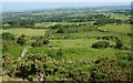
The land of the Moel y Ci Environmental Centre viewed from the lane to Sling
The land of the Moel y Ci Environmental Project extends southwards up-slope from the B4409 to the Sling Lane and beyond to the summit of Moel y Ci hill.
http://www.moelyci.org/
Image: © Eric Jones
Taken: 31 May 2008
0.20 miles
3
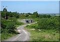
Welsh Water pumping station and covered reservoir on Lon Rallt
Image: © Eric Jones
Taken: 31 May 2008
0.24 miles
4
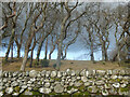
Coedlan ger Pant-y-Cyff / Woodland near Pant-y-Cyff (1)
Image: © Ceri Thomas
Taken: 6 Feb 2022
0.24 miles
5
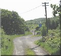
The end of the tarred section of Lon Rallt lane
Image: © Eric Jones
Taken: 31 May 2008
0.24 miles