IMAGES TAKEN NEAR TO
Aber Road, BANGOR, LL57 3YR
Introduction
This page details the photographs taken nearby to Aber Road, LL57 3YR by members of the Geograph project.
The Geograph project started in 2005 with the aim of publishing, organising and preserving representative images for every square kilometre of Great Britain, Ireland and the Isle of Man.

There are currently over 7.5m images from over14,400 individuals and you can help contribute to the project by visiting https://www.geograph.org.uk
Image Map
Images are licensed for reuse under creativecommons.org/licenses/by-sa/2.0
Notes
- Clicking on the map will re-center to the selected point.
- The higher the marker number, the further away the image location is from the centre of the postcode.
Image Listing (13 Images Found)
Images are licensed for reuse under creativecommons.org/licenses/by-sa/2.0
Image
Details
Distance

2
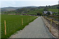
Temporary path along the road at Capel Gilfach
Image: © Mat Fascione
Taken: 17 Apr 2019
0.06 miles
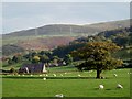
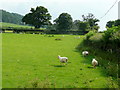
4
Sheep pasture at Tan-yr-allt
Looking south-east towards the north-west foothills of Snowdonia.
Coed Bronydd Isaf is the woodland on the hilltop.
Image: © Jonathan Billinger
Taken: 30 Jun 2009
0.12 miles
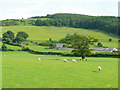
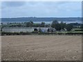
6
Pastoral scene
More pasture land at Tan-yr-allt - see Image
Image: © Jonathan Billinger
Taken: 30 Jun 2009
0.15 miles
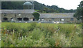
8

Lay-by and countdown marker heading West on the A55
Image: © Steve Fareham
Taken: 16 Jul 2012
0.16 miles
9

A55 Abergwyngregyn to Tai'r Meibion Improvement scheme plaque, Crymlyn
This bilingual plaque commemorates the completion of the A55 improvement scheme between near the village of Abergwyngregyn.
The improvement scheme was designed to increased the safety of traffic along this section of the A55 expressway as well as the construction of a cycle/footpath between the village of Abergwyngregyn and the hamlet of Tan-y-lôn.
The plaque is located on a large boulder about halfway along the cycle/footpath.
The text on the plaque reads:
UNDEB EWROPEAIDD
EUROPEAN UNION
Llywodraeth Cymru
Welsh Government
Cronfa Datblygu
Rhanbarthol Ewrop
European Regional
Development Fund
Mae'r plac hwn yn nodi cwblhau cynllun
Gwella'r A55 o Abergwyngregyn i Dai'r Meibion
Cynllun a ariannwyd gan Lywodraeth Cymru
a Chronfa Datblygu Rhanbarthol Ewrop
This plaque marks the completion of the
A55 Abergwyngregyn to Tai'r Meibion Improvement scheme
A scheme funded by the Welsh Government and European Regional Development Fund
Dadorchuddiwyd gan / Unveiled by
Lesley Griffiths AS / MS
Ebrill / April 2023
Y Gweinidog Materion Gwledig a Gogledd Cymru, a'r Trefnydd
Minister for Rural Affairs and North Wales, and Trefnydd
Asiant y Cyflogwr / Employer's Agent-YGC
Contractwr / Contractor - Alun Griffiths
Dylunydd yr Contractwr / Contractor's Designer - Atkins
See also Image
Image: © Meirion
Taken: 28 Jun 2024
0.17 miles
10
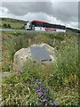
Large boulder next to the A55 with commemorative plaque, Crymlyn
See also Image
Image: © Meirion
Taken: 28 Jun 2024
0.17 miles