IMAGES TAKEN NEAR TO
Talybont, BANGOR, LL57 3UU
Introduction
This page details the photographs taken nearby to LL57 3UU by members of the Geograph project.
The Geograph project started in 2005 with the aim of publishing, organising and preserving representative images for every square kilometre of Great Britain, Ireland and the Isle of Man.

There are currently over 7.5m images from over14,400 individuals and you can help contribute to the project by visiting https://www.geograph.org.uk
Image Map
Images are licensed for reuse under creativecommons.org/licenses/by-sa/2.0
Notes
- Clicking on the map will re-center to the selected point.
- The higher the marker number, the further away the image location is from the centre of the postcode.
Image Listing (26 Images Found)
Images are licensed for reuse under creativecommons.org/licenses/by-sa/2.0
Image
Details
Distance

2
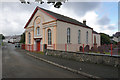
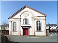
Capel Bethlehem, Tal-y-Bont
It is in good condition, but it is difficult to tell whether it is still active.
Image: © Bill Boaden
Taken: 18 Sep 2015
0.02 miles
7
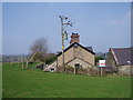
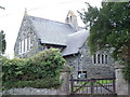
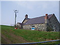
Electric Shadow
Gable end of Tyddyn Y Berth, Tal-y-bont.
Image: © J Scott
Taken: 3 Apr 2009
0.11 miles
8
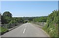
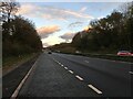
The A55 overbridge south of Tal-y-bont
This is the only straight and wide section of this notoriously narrow and winding lane leading to Llanllechid and Rachub which is used by the Arriva No 66 service.
Image: © Eric Jones
Taken: 31 May 2008
0.16 miles