IMAGES TAKEN NEAR TO
Carneddi, Bethesda, BANGOR, LL57 3UG
Introduction
This page details the photographs taken nearby to LL57 3UG by members of the Geograph project.
The Geograph project started in 2005 with the aim of publishing, organising and preserving representative images for every square kilometre of Great Britain, Ireland and the Isle of Man.

There are currently over 7.5m images from over14,400 individuals and you can help contribute to the project by visiting https://www.geograph.org.uk
Image Map
Images are licensed for reuse under creativecommons.org/licenses/by-sa/2.0
Notes
- Clicking on the map will re-center to the selected point.
- The higher the marker number, the further away the image location is from the centre of the postcode.
Image Listing (8 Images Found)
Images are licensed for reuse under creativecommons.org/licenses/by-sa/2.0
Image
Details
Distance
1
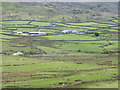
View across the in-by fields of Lower Cwm Ffrydan towards Parc Farm
Image: © Eric Jones
Taken: 11 May 2007
0.05 miles
2
Tan-y-garth rock cannon, Gerlan
A rock cannon (Craig fagnel) near Tan-y-garth farm, Gerlan. (See also: Image).
Image: © Meirion
Taken: 10 Aug 2016
0.19 miles
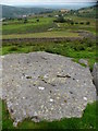
3
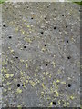
Tan-y-garth rock cannon (close-up of holes), Gerlan
A close-up of some of the holes in the rock cannon (Craig fagnel) near Tan-y-garth farm, Gerlan. (See also: Image).
Image: © Meirion
Taken: 10 Aug 2016
0.19 miles
4
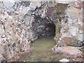
Trial levels above Tan-y-Garth, Gerlan.
This is one of the copper trial levels on the west side of Y Garth, not far from the old pumping station above Ciltwllan. The tunnel descends quickly and is flooded. There are others close by. Excavations started in 1783 by a Mr. Baker who may have been an agent of the Penrhyn Estate. The site yielded 232 tons of arsenic-pyrities according to David Bick's excellent book on Old Copper Mines of Snowdonia.
Image: © Elfyn Edwards
Taken: 14 Apr 2008
0.21 miles
5
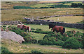
Ponies in the Frydlas Valley above Gerlan
Image: © Eric Jones
Taken: 19 Aug 1998
0.23 miles
6
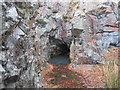
Entrance to old abandoned mine, Ciltwllan
The entrance to an old abandoned mine on Y Garth overlooking Ciltwllan and Bethesda.
Image: © Meirion
Taken: 15 Feb 2017
0.24 miles
7
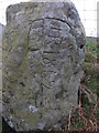
Inscribed rock in field wall, Gerlan
The most prominent feature looks like the data 1862? Possibly some type of boundary marker?
Image: © Meirion
Taken: 30 Nov 2016
0.25 miles
8
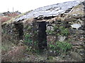
Ruined building in field, Gerlan
The ruined building in a field near Afon Ffrydlas.
Image: © Meirion
Taken: 30 Nov 2016
0.25 miles