IMAGES TAKEN NEAR TO
Upper Hill Street, BANGOR, LL57 3TE
Introduction
This page details the photographs taken nearby to Upper Hill Street, LL57 3TE by members of the Geograph project.
The Geograph project started in 2005 with the aim of publishing, organising and preserving representative images for every square kilometre of Great Britain, Ireland and the Isle of Man.

There are currently over 7.5m images from over14,400 individuals and you can help contribute to the project by visiting https://www.geograph.org.uk
Image Map
Images are licensed for reuse under creativecommons.org/licenses/by-sa/2.0
Notes
- Clicking on the map will re-center to the selected point.
- The higher the marker number, the further away the image location is from the centre of the postcode.
Image Listing (36 Images Found)
Images are licensed for reuse under creativecommons.org/licenses/by-sa/2.0
Image
Details
Distance
1
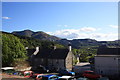
Short Street, Gerlan
Rows of terraced housing continuing up the hillside.
Image: © Bill Boaden
Taken: 18 Sep 2015
0.06 miles
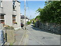
4
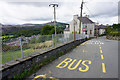
Gerlan Road, Gerlan
The road is descending towards the centre of Bethesda. Gerlan is the terminus of a bus route from Bangor, and there is a bus stop in the foreground.
Image: © Bill Boaden
Taken: 18 Sep 2015
0.08 miles
7
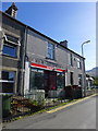
Gerlan: Spar
It would be great if someone could submit a photograph taken some years ago!
Image: © Hansjoerg Lipp
Taken: 2 Oct 2014
0.10 miles
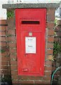
8
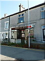
The former Gerlan Post Office and shop
Now closed and apparently abandoned.
Image: © Richard Law
Taken: 8 Jun 2023
0.11 miles
9
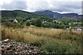
Hillside below Gerlan
This view looks across the southern side of Bethesda with the woods of Braich Melyn quite prominent. Beyond them is the Penrhyn slate quarry.
Image: © Bill Boaden
Taken: 18 Sep 2015
0.11 miles
10
View from parking bays on Gerlan Road
The houses in the foreground are a terrace of Well Street. In the background on the far (SW) side of the A5 and the Ogwen valley is Penrhyn Quarry with Carnedd y Filiast and Mynydd Perfedd to the left.
Note; I have superimposed a red "A" left of centre and a red "B" on the spoil heap mid right. These indicate the start and finish points of the longer of the two zip-wires which have been erected in the quarry. The zip-wire from A to B is 1600m long and is the longest in the northern hemisphere; speeds of up to 100mph can be achieved depending upon wind direction.
Image: © John Stephen
Taken: 7 Jun 2015
0.14 miles