IMAGES TAKEN NEAR TO
Glanffrydlas, BANGOR, LL57 3PF
Introduction
This page details the photographs taken nearby to Glanffrydlas, LL57 3PF by members of the Geograph project.
The Geograph project started in 2005 with the aim of publishing, organising and preserving representative images for every square kilometre of Great Britain, Ireland and the Isle of Man.

There are currently over 7.5m images from over14,400 individuals and you can help contribute to the project by visiting https://www.geograph.org.uk
Image Map
Images are licensed for reuse under creativecommons.org/licenses/by-sa/2.0
Notes
- Clicking on the map will re-center to the selected point.
- The higher the marker number, the further away the image location is from the centre of the postcode.
Image Listing (85 Images Found)
Images are licensed for reuse under creativecommons.org/licenses/by-sa/2.0
Image
Details
Distance
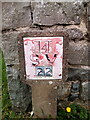
2
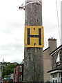
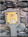
Hydrant sign on telephone pole on Pant Road, Bethesda
Image: © Meirion
Taken: 15 May 2020
0.03 miles
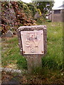
5
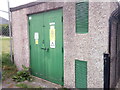
Adwyr Nant Substation on the High Street, Bethesda
See also: Image
Image: © Meirion
Taken: 15 May 2020
0.04 miles
6
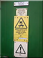
Signs at Adwyr Nant Substation on the High Street, Bethesda
See also: Image
Image: © Meirion
Taken: 15 May 2020
0.04 miles
7
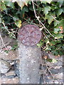
Remains of an old reflective roadside disc, Bethesda
Image: © Meirion
Taken: 15 Oct 2019
0.05 miles
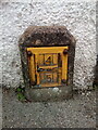
9
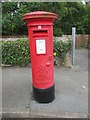
King George VI pillar box, Bethesda
LL57 280D
Image: © Meirion
Taken: 14 Aug 2019
0.05 miles