IMAGES TAKEN NEAR TO
Llanllechid, BANGOR, LL57 3EH
Introduction
This page details the photographs taken nearby to LL57 3EH by members of the Geograph project.
The Geograph project started in 2005 with the aim of publishing, organising and preserving representative images for every square kilometre of Great Britain, Ireland and the Isle of Man.

There are currently over 7.5m images from over14,400 individuals and you can help contribute to the project by visiting https://www.geograph.org.uk
Image Map
Images are licensed for reuse under creativecommons.org/licenses/by-sa/2.0
Notes
- Clicking on the map will re-center to the selected point.
- The higher the marker number, the further away the image location is from the centre of the postcode.
Image Listing (39 Images Found)
Images are licensed for reuse under creativecommons.org/licenses/by-sa/2.0
Image
Details
Distance
1
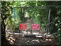
Llwybr Troed Ymlaen Ar Gau / Footway Ahead Closed, Rachub
Image: © Meirion
Taken: 8 Aug 2019
0.08 miles
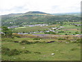
2

Panorama of field east of cemetery.
The image pans from ENE to SSE. from left to right, the view takes in Moel Wnion to Glydyr Fawr. The settlement to the left is Rachub and the mast in the centre is Tan-y-foel.
Image: © Anonymous
Taken: 6 Mar 2006
0.09 miles
3
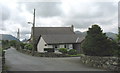
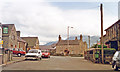
Stad Yr Ynys Estate and Capel Bethel (Bedyddwyr/Baptist)
Image: © Eric Jones
Taken: 11 May 2007
0.16 miles
4
Hydrant marker on Coetmor New Road, Bethesda
Image: © Meirion
Taken: 5 Nov 2019
0.17 miles
5
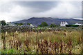
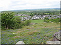
Fields on the edge of Rachub
Disused fields with dry stone walls. The mountains on the south side of the Ogwen valley are in cloud.
Image: © Bill Boaden
Taken: 18 Sep 2015
0.17 miles
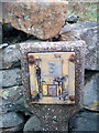
6
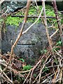
Benchmark on Llwyn Bleddyn Road, Rachub
For more details see: https://www.bench-marks.org.uk/bm29697
Image: © Meirion
Taken: 3 Mar 2022
0.17 miles
8
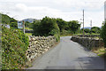
Ffordd Hen Barc, Rachub
This road runs south of Rachub village towards Bethesda.
Image: © Stephen McKay
Taken: 7 Aug 2017
0.18 miles
9
Llanllechid: to Snowdonia Mountains, 1993
View southward from by the Royal Oak Inn - cf. Image
Image: © Ben Brooksbank
Taken: 16 Jun 1993
0.19 miles
10
Coetmor New Road from the slopes of Moel Faban
The large building to the left of the road is the Ogwen Sports Centre. To the right are the grounds of the Bethesda Cricket and Bowling Clubs.
Image: © Eric Jones
Taken: 11 May 2007
0.20 miles