IMAGES TAKEN NEAR TO
Bethesda, BANGOR, LL57 3BQ
Introduction
This page details the photographs taken nearby to LL57 3BQ by members of the Geograph project.
The Geograph project started in 2005 with the aim of publishing, organising and preserving representative images for every square kilometre of Great Britain, Ireland and the Isle of Man.

There are currently over 7.5m images from over14,400 individuals and you can help contribute to the project by visiting https://www.geograph.org.uk
Image Map
Images are licensed for reuse under creativecommons.org/licenses/by-sa/2.0
Notes
- Clicking on the map will re-center to the selected point.
- The higher the marker number, the further away the image location is from the centre of the postcode.
Image Listing (41 Images Found)
Images are licensed for reuse under creativecommons.org/licenses/by-sa/2.0
Image
Details
Distance
5
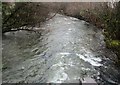
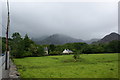
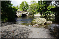
Afon Ogwen ger Coed Bryn Meurig / Afon Ogwen near Coed Bryn Meurig
Image: © Ceri Thomas
Taken: 17 Mar 2019
0.05 miles
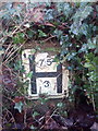
6
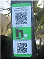
HiPoints information QR code at Pont Twr, Bethesda
HistoryPoints.org brings local history to your mobile phone. Main website at https://historypoints.org
Image: © Meirion
Taken: 23 Jan 2020
0.05 miles
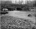
8
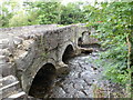
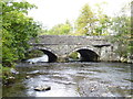
Afon Ogwen
The river has just about reached Bethesda. The bridge carries the B4409 which runs down the west side of the Ogwen to Tregarth.
Image: © Bill Boaden
Taken: 18 Sep 2015
0.06 miles