IMAGES TAKEN NEAR TO
Deiniol Road, BANGOR, LL57 2UW
Introduction
This page details the photographs taken nearby to Deiniol Road, LL57 2UW by members of the Geograph project.
The Geograph project started in 2005 with the aim of publishing, organising and preserving representative images for every square kilometre of Great Britain, Ireland and the Isle of Man.

There are currently over 7.5m images from over14,400 individuals and you can help contribute to the project by visiting https://www.geograph.org.uk
Image Map
Images are licensed for reuse under creativecommons.org/licenses/by-sa/2.0
Notes
- Clicking on the map will re-center to the selected point.
- The higher the marker number, the further away the image location is from the centre of the postcode.
Image Listing (545 Images Found)
Images are licensed for reuse under creativecommons.org/licenses/by-sa/2.0
Image
Details
Distance
2
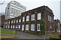
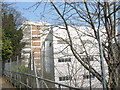
Adeiladau Thoday Buildings, Deiniol Road
These house part of the School of Environment and Natural Resources of Bangor University.
Image: © Eric Jones
Taken: 23 May 2009
0.02 miles
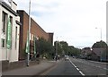
4
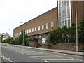
Laboratory building on the science campus of UCNW in Ffordd Deiniol
Image: © Eric Jones
Taken: 27 Mar 2007
0.03 miles
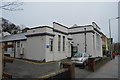
6
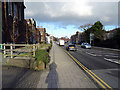
Ffordd Deiniol passing university
Entrance to car park on left
Image: © John Firth
Taken: 7 Oct 2013
0.03 miles
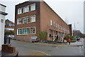
8
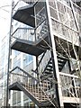
An elaborate fire escape on the Science Campus of UCNW
Image: © Eric Jones
Taken: 27 Mar 2007
0.04 miles
9
Science laboratories at University College of North Wales
Image: © Eric Jones
Taken: 27 Mar 2007
0.04 miles