IMAGES TAKEN NEAR TO
Caernarfon Road, BANGOR, LL57 2UT
Introduction
This page details the photographs taken nearby to Caernarfon Road, LL57 2UT by members of the Geograph project.
The Geograph project started in 2005 with the aim of publishing, organising and preserving representative images for every square kilometre of Great Britain, Ireland and the Isle of Man.

There are currently over 7.5m images from over14,400 individuals and you can help contribute to the project by visiting https://www.geograph.org.uk
Image Map
Images are licensed for reuse under creativecommons.org/licenses/by-sa/2.0
Notes
- Clicking on the map will re-center to the selected point.
- The higher the marker number, the further away the image location is from the centre of the postcode.
Image Listing (223 Images Found)
Images are licensed for reuse under creativecommons.org/licenses/by-sa/2.0
Image
Details
Distance
2
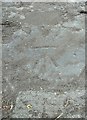
Benchmark on Caernarfon Road, Bangor
For more details see: https://www.bench-marks.org.uk/bm110280
Image: © Meirion
Taken: 1 Aug 2019
0.02 miles
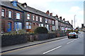
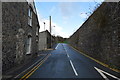
4
Chinese Take Away, Newsagents, a house, and the Berkeley Arms in Caernarfon Road
Image: © Eric Jones
Taken: 28 May 2007
0.03 miles
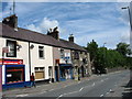
5
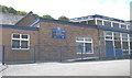
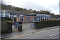
Ysgol Gynradd Gatholig Ein Harglwyddes : Our Lady's Catholic Primary School, Caernarfon Road
Image: © Eric Jones
Taken: 28 May 2007
0.04 miles
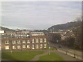
8
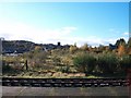
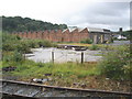
Overgrown marshalling yards at Bangor Station
The tower in the background is that of Eglwys Dewi Sant (St David's Church).
Image: © Eric Jones
Taken: 6 Nov 2010
0.05 miles

10
Former locomotive sheds, Bangor
Closed by BR, in 1965.
Image: © Roger Cornfoot
Taken: 17 Jul 2009
0.05 miles