IMAGES TAKEN NEAR TO
Siliwen Road, BANGOR, LL57 2SU
Introduction
This page details the photographs taken nearby to Siliwen Road, LL57 2SU by members of the Geograph project.
The Geograph project started in 2005 with the aim of publishing, organising and preserving representative images for every square kilometre of Great Britain, Ireland and the Isle of Man.

There are currently over 7.5m images from over14,400 individuals and you can help contribute to the project by visiting https://www.geograph.org.uk
Image Map
Images are licensed for reuse under creativecommons.org/licenses/by-sa/2.0
Notes
- Clicking on the map will re-center to the selected point.
- The higher the marker number, the further away the image location is from the centre of the postcode.
Image Listing (330 Images Found)
Images are licensed for reuse under creativecommons.org/licenses/by-sa/2.0
Image
Details
Distance
2
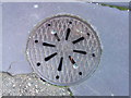
Possible coal hole and cover on Siliwen Road, Bangor
Garth Terrace
Image: © Meirion
Taken: 8 Nov 2019
0.01 miles
3
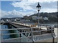
Inland view on Garth Pier, Bangor
Also referred to as Bangor Pier.
Image: © Robin Drayton
Taken: 28 Mar 2017
0.03 miles
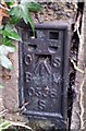
4

Flush bracket S0336 at Garth Gardens, Bangor
This flush bracket located on the gatepost at the upper entrance to the Garth Gardens in Bangor is shown in the Ordnance Survey database as being 17.0637m above the Newlyn datum.
Image: © Meirion
Taken: 11 Aug 2010
0.03 miles
5
Ordnance Survey Flush Bracket (S0336)
This OS Flush Bracket can be found on the Garden Wall. It marks a point 17.064m above mean sea level.
Image: © Adrian Dust
Taken: 31 Jan 2017
0.03 miles
6
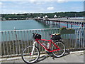
Garth, Bangor
The starting point of my Bangor - Cardiff bike ride.
Image: © easthantsxc
Taken: 24 Jun 2013
0.04 miles
7
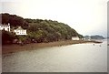
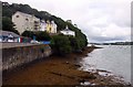
The shore of Bangor from Bangor Pier
The shore here has low cliffs topped by a wooded slope. The row of cottages is perilously near to the sea and must surely have been built for fishermen. This photo was taken in 1993, and I am not sure whereabouts on the pier it was taken from.
Image: © Humphrey Bolton
Taken: 22 Jul 1993
0.04 miles
8
Ristorante Pulcinella, Bangor
Italian restaurant located in the SW corner of the car park
alongside the entrance gates http://www.geograph.org.uk/photo/2913371 to Bangor Pier.
Image: © Jaggery
Taken: 24 Mar 2012
0.04 miles
9
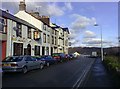
Upper Garth Road, Bangor
Looking north along Upper Garth Road towards the Strait. The 'Ship Launch' and, at the end of the row, 'The Tap and Spile' (together with the off-camera 'Boatyard Inn') make this a very pleasant street on which to spend some time.
Image: © mick finn
Taken: 30 Nov 2008
0.04 miles
10
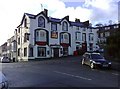
The 'Tap and Spile', Bangor
Fine looking pub on the corner of Upper Garth Road, Bangor.
Image: © mick finn
Taken: 30 Nov 2008
0.04 miles