IMAGES TAKEN NEAR TO
Sackville Terrace, Garth Road, BANGOR, LL57 2SG
Introduction
This page details the photographs taken nearby to Sackville Terrace, Garth Road, LL57 2SG by members of the Geograph project.
The Geograph project started in 2005 with the aim of publishing, organising and preserving representative images for every square kilometre of Great Britain, Ireland and the Isle of Man.

There are currently over 7.5m images from over14,400 individuals and you can help contribute to the project by visiting https://www.geograph.org.uk
Image Map
Images are licensed for reuse under creativecommons.org/licenses/by-sa/2.0
Notes
- Clicking on the map will re-center to the selected point.
- The higher the marker number, the further away the image location is from the centre of the postcode.
Image Listing (311 Images Found)
Images are licensed for reuse under creativecommons.org/licenses/by-sa/2.0
Image
Details
Distance
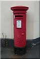
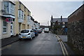
1
The Boat Yard, Bangor
Pub near the harbour which is now trying to appeal to a wider clientele.
Image: © Bill Boaden
Taken: 24 Mar 2012
0.01 miles
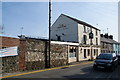
6
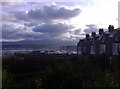
Boats in a Huddle
Looking from Upper Garth Street towards the jetty at Dickies Boatyard.
Image: © mick finn
Taken: 30 Nov 2008
0.03 miles
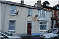
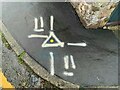
7
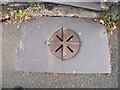
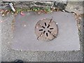
Possible coal hole and cover on Upper Garth Road, Bangor
Image: © Meirion
Taken: 10 Aug 2019
0.03 miles
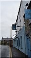
8
Possible coal hole and cover on Upper Garth Road, Bangor
Image: © Meirion
Taken: 10 Aug 2019
0.03 miles
9
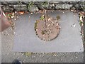
Possible coal hole and cover on Upper Garth Road, Bangor
Image: © Meirion
Taken: 10 Aug 2019
0.03 miles