IMAGES TAKEN NEAR TO
Treborth Road, BANGOR, LL57 2RJ
Introduction
This page details the photographs taken nearby to Treborth Road, LL57 2RJ by members of the Geograph project.
The Geograph project started in 2005 with the aim of publishing, organising and preserving representative images for every square kilometre of Great Britain, Ireland and the Isle of Man.

There are currently over 7.5m images from over14,400 individuals and you can help contribute to the project by visiting https://www.geograph.org.uk
Image Map
Images are licensed for reuse under creativecommons.org/licenses/by-sa/2.0
Notes
- Clicking on the map will re-center to the selected point.
- The higher the marker number, the further away the image location is from the centre of the postcode.
Image Listing (133 Images Found)
Images are licensed for reuse under creativecommons.org/licenses/by-sa/2.0
Image
Details
Distance
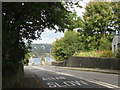
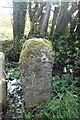
2

Old Milestone in Treborth Road, Bangor
Carved slate milestone alongside the A487 Treborth Road, south west of Bangor. Caernarvon chamfered slate. Probably late C19 and erected by the County Council. It is against the wall at the entrance to CAE FFOS and next to a public footpath, however, its location on old maps shows it further west at the other side of the house, so it has been moved a short distance from its original location.
Inscription reads:- : MILES / CARNARVON 7 / PORTDINORWIC 3 / MENAIBRIDGE 1 / BANGOR 2 :
Milestone Society National ID: CAE_BGCVA02.
Image: © Milestone Society
Taken: 17 Oct 2019
0.06 miles
3
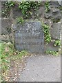
Milestone (Bangor 2), Treborth
An old slate milestone on the A487
CARNARVON 7
PORTDINORWIC 3
MENAI BRIDGE 1
BANGOR 2
Image: © Meirion
Taken: 13 Mar 2019
0.07 miles
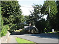
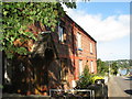
4
Traditional cottage near The Antelope Inn
Image: © Eric Jones
Taken: 9 Oct 2008
0.09 miles
5
Old Boundary Marker
Parish Boundary Marker on track or path between Penrhos Road and A487 Treborth Road. On the boundary of Pentir and Bangor communities. No inscription.
Milestone Society National ID: CAE_PENBAN02pb
Image: © D Elis-Williams
Taken: 10 Apr 2020
0.09 miles
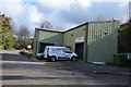
6
A terrace of red brick houses near the site of the old Menai Bridge railway station.
The Menai Bridge station was located on the mainland. The station was closed in the 1960s.
Image: © Eric Jones
Taken: 7 Sep 2007
0.09 miles
7
![The 08.38 [ex Bangor] Crewe to Holyhead train at Treborth](https://s3.geograph.org.uk/geophotos/01/44/10/1441051_3e66eac7_120x120.jpg)
The 08.38 [ex Bangor] Crewe to Holyhead train at Treborth
Image: © Eric Jones
Taken: 13 Aug 2009
0.13 miles
9
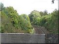
The Holyhead-Bangor railway line from Treborth Bridge
Image: © Eric Jones
Taken: 9 Oct 2008
0.13 miles