IMAGES TAKEN NEAR TO
Min Y Grug, BANGOR, LL57 2QB
Introduction
This page details the photographs taken nearby to Min Y Grug, LL57 2QB by members of the Geograph project.
The Geograph project started in 2005 with the aim of publishing, organising and preserving representative images for every square kilometre of Great Britain, Ireland and the Isle of Man.

There are currently over 7.5m images from over14,400 individuals and you can help contribute to the project by visiting https://www.geograph.org.uk
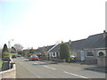
Image Map
Images are licensed for reuse under creativecommons.org/licenses/by-sa/2.0
Notes
- Clicking on the map will re-center to the selected point.
- The higher the marker number, the further away the image location is from the centre of the postcode.
Image Listing (45 Images Found)
Images are licensed for reuse under creativecommons.org/licenses/by-sa/2.0
Image
Details
Distance
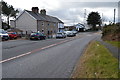
1
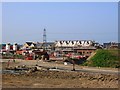
Construction of New Housing, Penrhos Garnedd
Image: © Chris Andrews
Taken: 10 Sep 2015
0.06 miles

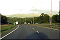
5
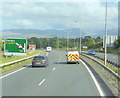
The A55 North Wales Expressway
Towards junction 10.
Image: © Ian S
Taken: 28 Aug 2014
0.13 miles
6
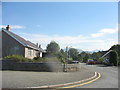
Ffordd Cynan Estate
This is part of the 1980s and 1990s housing development on the western outskirts of Bangor.
Image: © Eric Jones
Taken: 9 Sep 2006
0.15 miles
8
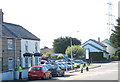
Welsh water leak diviners at Penrhosgarnedd
Image: © Eric Jones
Taken: 7 Sep 2007
0.16 miles