IMAGES TAKEN NEAR TO
Penrhosgarnedd, BANGOR, LL57 2PS
Introduction
This page details the photographs taken nearby to LL57 2PS by members of the Geograph project.
The Geograph project started in 2005 with the aim of publishing, organising and preserving representative images for every square kilometre of Great Britain, Ireland and the Isle of Man.

There are currently over 7.5m images from over14,400 individuals and you can help contribute to the project by visiting https://www.geograph.org.uk
Image Map
Images are licensed for reuse under creativecommons.org/licenses/by-sa/2.0
Notes
- Clicking on the map will re-center to the selected point.
- The higher the marker number, the further away the image location is from the centre of the postcode.
Image Listing (70 Images Found)
Images are licensed for reuse under creativecommons.org/licenses/by-sa/2.0
Image
Details
Distance
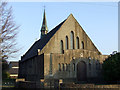
1
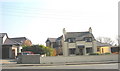
Llwyn Teg Cottage backed by the Dol Hyfryd Estate
Image: © Eric Jones
Taken: 31 Mar 2007
0.01 miles
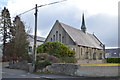
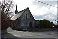
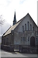
5
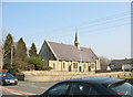
St . Peter's Church
St. Peter's church in Penrhos Garnedd, with evening sunlight on the building
Image: © Nigel Williams
Taken: 21 Apr 2006
0.04 miles
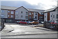
6
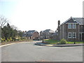
The Dol Hyfryd Estate - Bangor's most expensive houses
Image: © Eric Jones
Taken: 31 Mar 2007
0.04 miles
10
Cilgant Alotan Crescent off Penrhos Road
Image: © Eric Jones
Taken: 31 Mar 2007
0.05 miles