IMAGES TAKEN NEAR TO
Ffriddoedd Road, BANGOR, LL57 2GE
Introduction
This page details the photographs taken nearby to Ffriddoedd Road, LL57 2GE by members of the Geograph project.
The Geograph project started in 2005 with the aim of publishing, organising and preserving representative images for every square kilometre of Great Britain, Ireland and the Isle of Man.

There are currently over 7.5m images from over14,400 individuals and you can help contribute to the project by visiting https://www.geograph.org.uk
Image Map
Images are licensed for reuse under creativecommons.org/licenses/by-sa/2.0
Notes
- Clicking on the map will re-center to the selected point.
- The higher the marker number, the further away the image location is from the centre of the postcode.
Image Listing (73 Images Found)
Images are licensed for reuse under creativecommons.org/licenses/by-sa/2.0
Image
Details
Distance
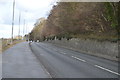
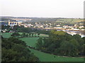
2
Ffordd Caergybi (Holyhead Road) towards Bangor
Image: © JThomas
Taken: 16 Apr 2024
0.06 miles
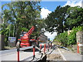
3
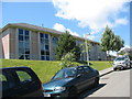
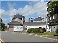
Site reception building on the Ffriddoedd residential site of UCNW Bangor
Image: © Eric Jones
Taken: 19 Jun 2008
0.07 miles
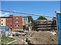
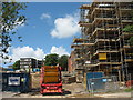
5
Construction work on the Bangor University Halls of Residence site in Ffriddoedd Road
Image: © Eric Jones
Taken: 19 Jun 2008
0.08 miles
6
Side view of the new hall of residence on the Ffriddoedd site
http://www.bangor.ac.uk/news/FfriddRedevel.php.en
Image: © Eric Jones
Taken: 19 Jun 2008
0.09 miles
7
Y Borth Residential Hall, Ffriddoedd Site, UCNW Bangor
Image: © Eric Jones
Taken: 19 Jun 2008
0.09 miles
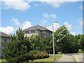
8
Halls of residence on the Ffriddoedd site of UCNW Bangor
Image: © Eric Jones
Taken: 19 Jun 2008
0.09 miles
9
New university hall of residence on the Ffriddoedd site
Image: © Eric Jones
Taken: 19 Jun 2008
0.09 miles