IMAGES TAKEN NEAR TO
Farrar Road, BANGOR, LL57 2DU
Introduction
This page details the photographs taken nearby to Farrar Road, LL57 2DU by members of the Geograph project.
The Geograph project started in 2005 with the aim of publishing, organising and preserving representative images for every square kilometre of Great Britain, Ireland and the Isle of Man.

There are currently over 7.5m images from over14,400 individuals and you can help contribute to the project by visiting https://www.geograph.org.uk
Image Map
Images are licensed for reuse under creativecommons.org/licenses/by-sa/2.0
Notes
- Clicking on the map will re-center to the selected point.
- The higher the marker number, the further away the image location is from the centre of the postcode.
Image Listing (374 Images Found)
Images are licensed for reuse under creativecommons.org/licenses/by-sa/2.0
Image
Details
Distance
5
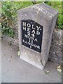
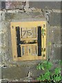
A Telford milestone (Holyhead 24) on Holyhead Road, Bangor
This is one of Thomas Telford's milestones located along the original London - Holyhead Road (A5). This one indicates that Holyhead is 24 miles away. The milestone also has a 1GL benchmark carved into the stone. See also: Image
Image: © Meirion
Taken: 25 Aug 2010
0.04 miles
6
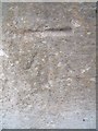
1GL benchmark on milestone (Holyhead 24) on Holyhead Road, Bangor
This worn 1GL benchmark located on one of Thomas Telford's original milestones on Holyhead Road in Bangor was used during the Ordnance Survey's First Primary Levelling on the line between Warrington and Pembroke Docks, between September 1851 and July 1852. This mark was mark No.2 on a branch line between Bangor and Holyhead. The Ordnance Survey database shows that this mark was last inspected in 1955 and is 41.6753m above the Newlyn datum. See also: Image
Image: © Meirion
Taken: 25 Aug 2010
0.04 miles
7
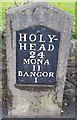
Milestone - Holyhead 24
There is an OS cut mark on the stone which marks a point 41.675m above mean sea level
Image: © Adrian Dust
Taken: 31 Jan 2017
0.04 miles
8
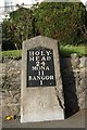
Old Milestone by the A5122, Holyhead Road, Bangor
Telford Plate by the A5122 (was A5), in parish of Bangor (Gwynedd District), Holyhead Road, opposite Farrar Road.
Inscription reads:-
HOLY-
HEAD
24
MONA
11
BANGOR
1
Carved benchmark on face.
Surveyed
Milestone Society National ID: CAE_HH24.
Image: © Milestone Society
Taken: Unknown
0.04 miles
10
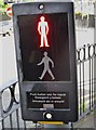
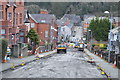
Bilingual pedestrian crossing instructions on Ffordd Deiniol Road, Bangor
Image: © Eric Jones
Taken: 16 Jun 2015
0.05 miles