IMAGES TAKEN NEAR TO
BANGOR, LL57 1ZB
Introduction
This page details the photographs taken nearby to LL57 1ZB by members of the Geograph project.
The Geograph project started in 2005 with the aim of publishing, organising and preserving representative images for every square kilometre of Great Britain, Ireland and the Isle of Man.

There are currently over 7.5m images from over14,400 individuals and you can help contribute to the project by visiting https://www.geograph.org.uk
Image Map
Images are licensed for reuse under creativecommons.org/licenses/by-sa/2.0
Notes
- Clicking on the map will re-center to the selected point.
- The higher the marker number, the further away the image location is from the centre of the postcode.
Image Listing (201 Images Found)
Images are licensed for reuse under creativecommons.org/licenses/by-sa/2.0
Image
Details
Distance
2
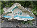
Railway Institute Date Stone
The date stone that sat above the entrance to the L & N. W. Railway Institute on Euston Rd, Bangor. The building was demolished 2016 in preparation for a new development. The date stone now sits on the ground in the parking area. No new development has been built as of 2021
Image: © Sion Jones
Taken: 26 Sep 2021
0.03 miles
3
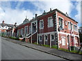
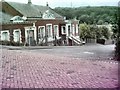
The Railway Institute, Bangor, Gwynydd
Dated 1905 and sited near the old railway yard this is or was a working men's club. Still in use I think.
Image: © Jeremy Bolwell
Taken: 15 May 2012
0.04 miles
4
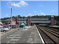
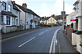
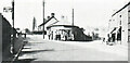
Bangor Station
This large ex-LNWR built station is situated between two tunnels as it crosses the valley. This view is looking in the "up" direction, SE as the line heads towards Chester.
Image: © David Stowell
Taken: 17 Aug 2005
0.05 miles
5
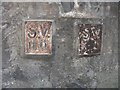
A pair of old Sluice valve markers on Penchwintan Road, Bangor
Image: © Meirion
Taken: 1 Aug 2019
0.05 miles
7
Railway Institute, Euston Road, Bangor
The Railway Institute was opened in 1905, for the express benefit of railway workers employed in the Bangor area and is still flourishing as a place of leisure and entertainment in 2009, although the membership is no longer expressly railway employees. Visible on the horizon, above the tree line, the mast on Bangor Mountain supporting microwave aerials, can be faintly observed
Image: © Bill Lovelock
Taken: 25 Oct 2007
0.06 miles
10
Toll House, A4087, Bangor
In the fork of Penchwintan and Caernarfon Roads (Pen-y-chwintan and Carnarvon roads in 1900). The Toll House was demolished shortly after this photo was taken in 1936. It served the Caernarvonshire Old Turnpike Trust up to the mid 18ᵗʰ C.
Milestone Society National ID: GWY.BAN2
Image: © David Elis-Williams (owner of photograph)
Taken: 1 Jan 1936
0.08 miles