IMAGES TAKEN NEAR TO
High Street, BANGOR, LL57 1NS
Introduction
This page details the photographs taken nearby to High Street, LL57 1NS by members of the Geograph project.
The Geograph project started in 2005 with the aim of publishing, organising and preserving representative images for every square kilometre of Great Britain, Ireland and the Isle of Man.

There are currently over 7.5m images from over14,400 individuals and you can help contribute to the project by visiting https://www.geograph.org.uk
Image Map
Images are licensed for reuse under creativecommons.org/licenses/by-sa/2.0
Notes
- Clicking on the map will re-center to the selected point.
- The higher the marker number, the further away the image location is from the centre of the postcode.
Image Listing (424 Images Found)
Images are licensed for reuse under creativecommons.org/licenses/by-sa/2.0
Image
Details
Distance
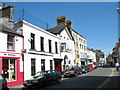
1
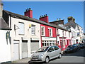
Shops in the High Street
The top part of the High Street is characterised by small shops and enterprises.
Image: © Eric Jones
Taken: 30 Apr 2007
0.00 miles
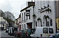
2

The Black Bull Inn
The Wetherspoon's in Bangor.
Image: © Bill Boaden
Taken: 24 Mar 2012
0.00 miles
4
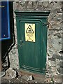
Old electrical cabinet just off the High Street, Bangor
Image: © Meirion
Taken: 7 May 2020
0.01 miles
5
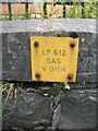
Gas valve marker on the High Street, Bangor
Image: © Meirion
Taken: 17 May 2020
0.01 miles
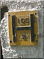
6
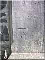
Benchmark on gatepost at Capel Pendref, Bangor
For more details see: https://www.bench-marks.org.uk/bm20977
Image: © Meirion
Taken: 31 Jul 2019
0.01 miles
7
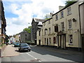
The Harp Inn and Capel Pendref (Welsh Independents)
Image: © Eric Jones
Taken: 28 May 2007
0.01 miles
9
Mr Maxwell's and Mr Wetherspoon's establishments
http://www.jdwetherspoon.co.uk/pubfinder/details.php?OutletNumber=90
Image: © Eric Jones
Taken: 30 Apr 2007
0.02 miles
10

Pendref Welsh Independent Chapel
Built in 1882 to the design of architect Owen Williams of Bangor. Grade II listed.
Image: © Richard Hoare
Taken: 10 Jun 2022
0.02 miles