IMAGES TAKEN NEAR TO
Gwern Las, BANGOR, LL57 1NF
Introduction
This page details the photographs taken nearby to Gwern Las, LL57 1NF by members of the Geograph project.
The Geograph project started in 2005 with the aim of publishing, organising and preserving representative images for every square kilometre of Great Britain, Ireland and the Isle of Man.

There are currently over 7.5m images from over14,400 individuals and you can help contribute to the project by visiting https://www.geograph.org.uk
Image Map
Images are licensed for reuse under creativecommons.org/licenses/by-sa/2.0
Notes
- Clicking on the map will re-center to the selected point.
- The higher the marker number, the further away the image location is from the centre of the postcode.
Image Listing (29 Images Found)
Images are licensed for reuse under creativecommons.org/licenses/by-sa/2.0
Image
Details
Distance
1
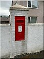
Queen Elizabeth II post box on Penrhyn Avenue, Maesgeirchen
LL57 62D
Image: © Meirion
Taken: 6 May 2022
0.07 miles
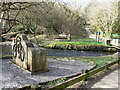
3
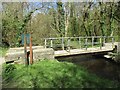
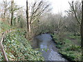
Bishop's Mill bridge over Afon Cegin, Bangor
Image: © Meirion
Taken: 20 Apr 2018
0.10 miles
4
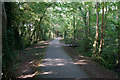
L?n Las Ogwen near the industrial estate
The estate is quite well hidden to the right.
Image: © David Medcalf
Taken: 25 Nov 2021
0.11 miles
5
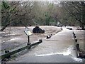
Afon Cegin, Bishop's Mill
High rainfall from Storm Eva, results in the river 'over topping'.
Image: © Chris Andrews
Taken: 26 Dec 2015
0.11 miles
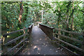
8
Foot and cycle path east of the Maesgeirchen estate, Bangor
Crossing the Cegin River
Image: © Eirian Evans
Taken: 19 Mar 2012
0.12 miles
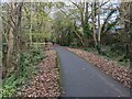
9
Afon Cegin at Maesgeirchen
Lon Las Cymru, a Sustrans route, follows the river here
Image: © Eirian Evans
Taken: 19 Mar 2012
0.13 miles
10
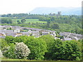
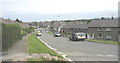
Part of the Maesgeirchen Housing Estate
Maesgeirchen (=oatfield) is the third largest local authority estate in Wales. It was developed initially in the late 1930s as part of a slum clearance scheme, and in 1941 suffered the attention of the Luftwaffe. In the local parlance, it is often referred to simply as Maes-G. The estate lies in the shadow of Penrhyn Castle, seen in the background.
http://en.wikipedia.org/wiki/Maesgeirchen
http://www.matrasite.netfirms.com/Site/history.html
Image: © Eric Jones
Taken: 21 May 2008
0.14 miles