IMAGES TAKEN NEAR TO
Station Road, BANGOR, LL57 1LZ
Introduction
This page details the photographs taken nearby to Station Road, LL57 1LZ by members of the Geograph project.
The Geograph project started in 2005 with the aim of publishing, organising and preserving representative images for every square kilometre of Great Britain, Ireland and the Isle of Man.

There are currently over 7.5m images from over14,400 individuals and you can help contribute to the project by visiting https://www.geograph.org.uk
Image Map
Images are licensed for reuse under creativecommons.org/licenses/by-sa/2.0
Notes
- Clicking on the map will re-center to the selected point.
- The higher the marker number, the further away the image location is from the centre of the postcode.
Image Listing (291 Images Found)
Images are licensed for reuse under creativecommons.org/licenses/by-sa/2.0
Image
Details
Distance
2
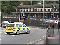
British Transport Police vehicle entering the concourse of Bangor Station
The word "Heddlu" on the side of the vehicle is Welsh for "Police" The British Transport Police, who have a police station at Bangor railway station, are known in Welsh as Heddlu Trafnidiaeth Prydeinig.
Image: © Eric Jones
Taken: 24 Aug 2009
0.02 miles
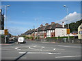
4
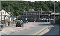
Road junction outside Bangor Railway Station
This is the junction of Holyhead Road (from which this image was taken) and Deiniol Road. The long brick built building is Bangor Railway Station.
Image: © Eric Jones
Taken: 24 Jul 2009
0.02 miles
5
Turning into Deiniol Road
This image is taken from the entrance to Bangor Railway Station.
Image: © Eric Jones
Taken: 24 Jul 2009
0.02 miles
6
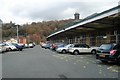
Bangor Station
Former Eastbound platform in Bangor station, now part of the car park.
Image: © Kevin Williams
Taken: 24 Nov 2010
0.03 miles
7
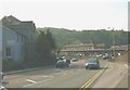
View down Holyhead Road towards Bangor Station
Image: © Eric Jones
Taken: 7 May 2008
0.03 miles
8
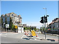
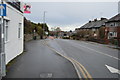
The junction of Station Road and Deiniol Road
Image: © Eric Jones
Taken: 30 Apr 2007
0.03 miles
10
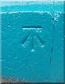
1GL benchmark on railway station booking office, Bangor
This 1GL benchmark located on the southeast face of the booking office at Bangor railway station was used during the Ordnance Survey's First Primary Levelling on the line between Warrington and Pembroke Docks, between September 1851 and July 1852. This mark was mark No.1 on a branch line between Bangor and Holyhead. The Ordnance Survey database shows that this mark was last inspected in 1974 and is 33.5449m above the Newlyn datum.
Image: © Meirion
Taken: 25 Aug 2010
0.03 miles