IMAGES TAKEN NEAR TO
Minafon, BANGOR, LL57 1LF
Introduction
This page details the photographs taken nearby to Minafon, LL57 1LF by members of the Geograph project.
The Geograph project started in 2005 with the aim of publishing, organising and preserving representative images for every square kilometre of Great Britain, Ireland and the Isle of Man.

There are currently over 7.5m images from over14,400 individuals and you can help contribute to the project by visiting https://www.geograph.org.uk
Image Map
Images are licensed for reuse under creativecommons.org/licenses/by-sa/2.0
Notes
- Clicking on the map will re-center to the selected point.
- The higher the marker number, the further away the image location is from the centre of the postcode.
Image Listing (550 Images Found)
Images are licensed for reuse under creativecommons.org/licenses/by-sa/2.0
Image
Details
Distance
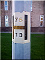
1
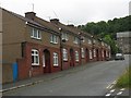
Terraced housing in Treflan Street, Bangor
Image: © Eric Jones
Taken: 20 Jun 2009
0.02 miles
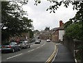
6
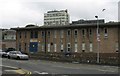
The Bangor University Computing Laboratories, Sackville Road
Image: © Eric Jones
Taken: 20 Jun 2009
0.03 miles
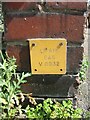
7
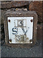
Sluice valve marker on Sackville Road, Bangor
Image: © Meirion
Taken: 20 Mar 2020
0.03 miles
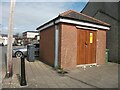
9
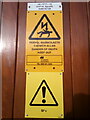
Signs at Kyffin Square substation, Bangor
See also: Image
Image: © Meirion
Taken: 20 Mar 2020
0.03 miles
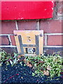
10
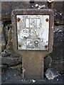
Sluice valve marker on Sackville Road, Bangor
Image: © Meirion
Taken: 20 Mar 2020
0.04 miles