IMAGES TAKEN NEAR TO
Strand Street, BANGOR, LL57 1DH
Introduction
This page details the photographs taken nearby to Strand Street, LL57 1DH by members of the Geograph project.
The Geograph project started in 2005 with the aim of publishing, organising and preserving representative images for every square kilometre of Great Britain, Ireland and the Isle of Man.

There are currently over 7.5m images from over14,400 individuals and you can help contribute to the project by visiting https://www.geograph.org.uk
Image Map
Images are licensed for reuse under creativecommons.org/licenses/by-sa/2.0
Notes
- Clicking on the map will re-center to the selected point.
- The higher the marker number, the further away the image location is from the centre of the postcode.
Image Listing (209 Images Found)
Images are licensed for reuse under creativecommons.org/licenses/by-sa/2.0
Image
Details
Distance
1
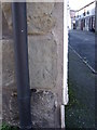
Benchmark at 1 Robert Street, Bangor
This worn benchmark is located on the E angle of No. 1 Robert Street in Bangor & it is shown in the current Ordnance Survey database at a height of 8.8123m above the Newlyn datum.
Image: © Meirion
Taken: 10 Feb 2011
0.02 miles
2
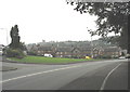
Maes Isalaw from the junction of the High Street and Beach Road
Image: © Eric Jones
Taken: 12 Oct 2007
0.03 miles
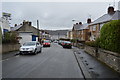
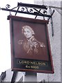
6
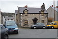
Beach Road Bangor
Looking down Beach Road Bangor. The Lord Nelson public house is seen on the left.
Image: © Andrew Woodvine
Taken: 28 Apr 2017
0.03 miles