IMAGES TAKEN NEAR TO
Y FELINHELI, LL56 4QW
Introduction
This page details the photographs taken nearby to LL56 4QW by members of the Geograph project.
The Geograph project started in 2005 with the aim of publishing, organising and preserving representative images for every square kilometre of Great Britain, Ireland and the Isle of Man.

There are currently over 7.5m images from over14,400 individuals and you can help contribute to the project by visiting https://www.geograph.org.uk
Image Map (Loading...)


Getting Data...Please wait
Leaflet Map data © OpenStreetMap
Images are licensed for reuse under creativecommons.org/licenses/by-sa/2.0
Notes
- Clicking on the map will re-center to the selected point.
- The higher the marker number, the further away the image location is from the centre of the postcode.
Image Listing (8 Images Found)
Images are licensed for reuse under creativecommons.org/licenses/by-sa/2.0
Image
Details
Distance
1
Layby on Felinheli bypass
Near Bodandreg
Image: © John Firth
Taken: 17 Oct 2016
0.13 miles
2
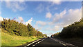
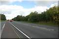
Ffordd osgoi Y Felinheli Bypass
Looking in the direction of Caernarfon from the summit laybay
Image: © Alan Fryer
Taken: 7 Oct 2015
0.13 miles
4
Plac yn nodi agor y ffordd osgoi Y Felinheli - Plaque marking the opening of the Felinheli bypass
For a close-up view of the text see Image
Image: © Alan Fryer
Taken: 7 Oct 2015
0.15 miles
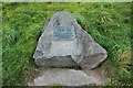
5
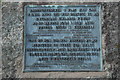
Plac yn nodi agor y ffordd osgoi Y Felinheli - Plaque marking the opening of the Felinheli bypass
A close-up of Image
Image: © Alan Fryer
Taken: 7 Oct 2015
0.15 miles
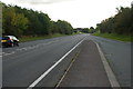
6
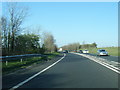
Ffordd osgoi Y Felinheli Bypass
Looking towards the summit in the direction of Bangor
Image: © Alan Fryer
Taken: 7 Oct 2015
0.18 miles
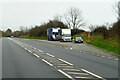
8

Truck on the Y Felinheli Bypass (A487)
DAF XF (CX18 MON) on the A487 near Y Felinheli.
Image: © David Dixon
Taken: 15 Feb 2022
0.19 miles