IMAGES TAKEN NEAR TO
Nantmor, CAERNARFON, LL55 4YL
Introduction
This page details the photographs taken nearby to LL55 4YL by members of the Geograph project.
The Geograph project started in 2005 with the aim of publishing, organising and preserving representative images for every square kilometre of Great Britain, Ireland and the Isle of Man.

There are currently over 7.5m images from over14,400 individuals and you can help contribute to the project by visiting https://www.geograph.org.uk
Image Map (Loading...)


Getting Data...Please wait
Leaflet Map data © OpenStreetMap
Images are licensed for reuse under creativecommons.org/licenses/by-sa/2.0
Notes
- Clicking on the map will re-center to the selected point.
- The higher the marker number, the further away the image location is from the centre of the postcode.
Image Listing (8 Images Found)
Images are licensed for reuse under creativecommons.org/licenses/by-sa/2.0
Image
Details
Distance

4

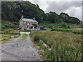
Bracken, woods and rocks near Beudy-Newydd
Image: © David Medcalf
Taken: 2 Jul 2023
0.09 miles
5

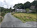
Five natural bars
A five-bar gate made with branches, not planks.
Image: © David Medcalf
Taken: 2 Jul 2023
0.12 miles
7

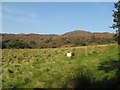
Not quite a roche moutonnée
Glacier-smoothed rocks above the track.
Image: © David Medcalf
Taken: 4 Jul 2023
0.19 miles
8
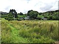
Improved fields
Sheep pasture below Cwm-caeth. The contrast with the 'mountain' beyond is marked.
Image: © Jonathan Wilkins
Taken: 21 Sep 2020
0.19 miles