IMAGES TAKEN NEAR TO
Llanberis, CAERNARFON, LL55 4SR
Introduction
This page details the photographs taken nearby to LL55 4SR by members of the Geograph project.
The Geograph project started in 2005 with the aim of publishing, organising and preserving representative images for every square kilometre of Great Britain, Ireland and the Isle of Man.

There are currently over 7.5m images from over14,400 individuals and you can help contribute to the project by visiting https://www.geograph.org.uk
Image Map (Loading...)


Getting Data...Please wait
Leaflet Map data © OpenStreetMap
Images are licensed for reuse under creativecommons.org/licenses/by-sa/2.0
Notes
- Clicking on the map will re-center to the selected point.
- The higher the marker number, the further away the image location is from the centre of the postcode.
Image Listing (22 Images Found)
Images are licensed for reuse under creativecommons.org/licenses/by-sa/2.0
Image
Details
Distance
1
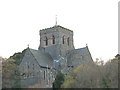
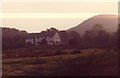
Eglwys Padarn Sant - St Padarn's Church
This large church was built in 1885 when the slate industry was at its peak. It was further extended in 1912.
Image: © Eric Jones
Taken: 2 Dec 2006
0.09 miles
2
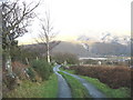
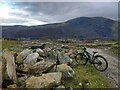
The mountain road from Llanberis to Waunfawr
This is a tarred road for about a mile, when it becomes a green lane. After another two miles it reverts to becoming a tarred road which descends from near Chwarel Fawr to Waunfawr. This view is taken looking back in the direction of Llanberis.
Image: © Eric Jones
Taken: 5 Jan 2007
0.09 miles
3
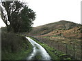
A steep section of the Llanberis-Waunfawr mountain road
Image: © Eric Jones
Taken: 5 Jan 2007
0.09 miles
4
Ty'r-mawn
Ty'r-mawn (house of the turf) situated above Hafod Lydan Farm is accessed by a footpath from both the farm and the green lane which runs from the Llanberis-Waunfawr road.
Image: © Eric Jones
Taken: 5 Jan 2007
0.09 miles
5
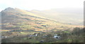
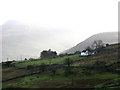
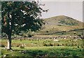
Fferm Hafod Lydan Farm
The Davies family of Hafod Lydan farm large tracts of the mountain area above Llanberis, mainly on the Llanberis side of the Moel Eilio range, but also on Snowdon around Hebron Chapel. The chapel can be seen to the right of the mountain railway track. The green fields in the foreground are the in-by fields of the farm.
Image: © Eric Jones
Taken: 5 Jan 2007
0.09 miles
6
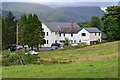
Llanberis Youth Hostel
Looking up the hillside to youth hostel. http://www.yha.org.uk/find-accommodation/wales/hostels/Llanberis/facilities.aspx
In the background on the right is Moel Elio, one of the lower summits below Snowdon.
Image: © Michael Westley
Taken: Unknown
0.15 miles
10
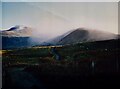
Early morning hill fog on Foel Goch and Moel Cynghorion
The photo was taken on the Llanberis to Ty'n-yr-aelgerth road. The track up the Maesgwm valley can be seen in the distance cutting across the lower slopes of Foel Goch. 'Aelgerth' means 'brow of the hill'
Image: © Eric Jones
Taken: 17 Feb 1998
0.19 miles