IMAGES TAKEN NEAR TO
Ceunant, CAERNARFON, LL55 4RY
Introduction
This page details the photographs taken nearby to LL55 4RY by members of the Geograph project.
The Geograph project started in 2005 with the aim of publishing, organising and preserving representative images for every square kilometre of Great Britain, Ireland and the Isle of Man.

There are currently over 7.5m images from over14,400 individuals and you can help contribute to the project by visiting https://www.geograph.org.uk
Image Map (Loading...)


Getting Data...Please wait
Leaflet Map data © OpenStreetMap
Images are licensed for reuse under creativecommons.org/licenses/by-sa/2.0
Notes
- Clicking on the map will re-center to the selected point.
- The higher the marker number, the further away the image location is from the centre of the postcode.
Image Listing (11 Images Found)
Images are licensed for reuse under creativecommons.org/licenses/by-sa/2.0
Image
Details
Distance
1
House in Ceunant
On the west side of the Waunfawr - Llanrug road.
Image: © Christine Johnstone
Taken: 22 Nov 2014
0.01 miles
2
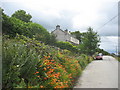
Roadside crocosmia at Ceunant
Crocosmia 'Lucifer' grows wild along the roadside in the linear upland hamlet of Ceunant.
Image: © Eric Jones
Taken: 11 Aug 2006
0.04 miles
3
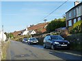
The Waunfawr - Llanrug road at Ceunant
Looking north-east.
Image: © Christine Johnstone
Taken: 22 Nov 2014
0.04 miles
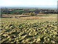
4
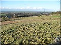
Rough pasture and broken-down walls, Ceunant
On the west side of the Waunfawr - Llanrug road.
Image: © Christine Johnstone
Taken: 22 Nov 2014
0.04 miles
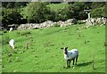
6
Pasture south-east of Glasfryn, Ceunant
'Glas' means green or blue, which is appropriate for this hillside.
Image: © Christine Johnstone
Taken: 22 Nov 2014
0.07 miles
7
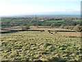
Cattle with a distant view of Caernarfon, Ceunant
Looking west from the Waunfawr - Llanrug road.
Image: © Christine Johnstone
Taken: 22 Nov 2014
0.09 miles
8
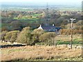
Glasfryn, Ceunant
Below [west of] the Waunfawr - Llanrug road.
Image: © Christine Johnstone
Taken: 22 Nov 2014
0.12 miles
9
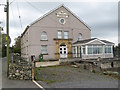
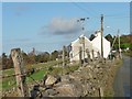
Capel Ceunant
The former chapel dated 1887 is now a private residence.
Image: © Jonathan Wilkins
Taken: 14 Oct 2011
0.17 miles
10
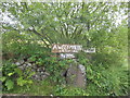
Roadside signage at Ceunant
These signs at the junction between the main road and a dirt track leading up to the Cefn Du moor lists the small holdings along the track. 'Awel-y-Mynydd' means mountain breeze, 'Ty Uchaf' = upper house, and 'Ty Isaf'= lower house.
Image: © Eric Jones
Taken: 11 Aug 2006
0.18 miles