IMAGES TAKEN NEAR TO
Llanrug, CAERNARFON, LL55 4RA
Introduction
This page details the photographs taken nearby to LL55 4RA by members of the Geograph project.
The Geograph project started in 2005 with the aim of publishing, organising and preserving representative images for every square kilometre of Great Britain, Ireland and the Isle of Man.

There are currently over 7.5m images from over14,400 individuals and you can help contribute to the project by visiting https://www.geograph.org.uk
Image Map
Images are licensed for reuse under creativecommons.org/licenses/by-sa/2.0
Notes
- Clicking on the map will re-center to the selected point.
- The higher the marker number, the further away the image location is from the centre of the postcode.
Image Listing (9 Images Found)
Images are licensed for reuse under creativecommons.org/licenses/by-sa/2.0
Image
Details
Distance
1
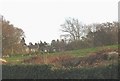
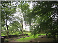
Pant Afon
This former manor has been sub-divided into three houses.
Image: © Eric Jones
Taken: 29 Nov 2008
0.02 miles
2
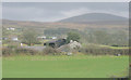
Drws-y-ddeugoed - a smallholding
Drws-y-ddeugoed translates as "door/gap between the two woodlands"
Image: © Eric Jones
Taken: 7 Mar 2008
0.18 miles
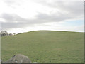
3
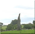
Standing Stone
This is one of a number of standing stones in the area. All are Victorian Follies, erected on the summits of knolls and drumlins of his estate by General Sir Hugh Rowlands V.C of Plastirion Image As children we were taught that old 'Syr Huw' added another stone each time he won a battle.
Image: © Eric Jones
Taken: 12 Aug 2006
0.21 miles
4
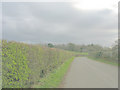
Well trimmed hedges along the Pencefn road
These hedges belong to Plas Tirion Farm. The house in the distance is the main lodge of Pant Afon.
Image: © Eric Jones
Taken: 7 Mar 2008
0.21 miles
5
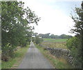
Country lane near Pant Ifan
This lane is used mainly by farmers to gain access to their fields. The narrowness of the road, its steep hills and sharp bends tend to deter other motorists.
Image: © Eric Jones
Taken: 12 Aug 2006
0.22 miles
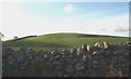
8
Drumlin topped with a standing stone
This stone, one of a number in the area, dates back to the days of the Crimean War hero, General Sir Hugh Rowlands V.C. of Plas Tirion Hall. Sir Hugh had a fondness for mock antiquities. As children we were told that each stone stood for one of the scores of battles Sir Hugh had won almost singlehandedly.
Image: © Eric Jones
Taken: 7 Mar 2008
0.24 miles
9
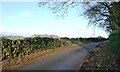
A road to Llanrug
Shaded by a small wood at the crossroads west of Pant Ifan.
Image: © Christine Johnstone
Taken: 22 Nov 2014
0.25 miles