IMAGES TAKEN NEAR TO
Rock Terrace, CAERNARFON, LL55 4LA
Introduction
This page details the photographs taken nearby to Rock Terrace, LL55 4LA by members of the Geograph project.
The Geograph project started in 2005 with the aim of publishing, organising and preserving representative images for every square kilometre of Great Britain, Ireland and the Isle of Man.

There are currently over 7.5m images from over14,400 individuals and you can help contribute to the project by visiting https://www.geograph.org.uk
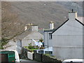
Image Map
Images are licensed for reuse under creativecommons.org/licenses/by-sa/2.0
Notes
- Clicking on the map will re-center to the selected point.
- The higher the marker number, the further away the image location is from the centre of the postcode.
Image Listing (126 Images Found)
Images are licensed for reuse under creativecommons.org/licenses/by-sa/2.0
Image
Details
Distance
1

Newton Street from Goodman Street, Llanberis
Image: © Eric Jones
Taken: 10 Jan 2007
0.03 miles
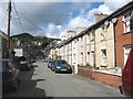
4
Stryd Goodman, Rallt Goch and Stryd Ianci
Image: © Eric Jones
Taken: 25 Jan 2007
0.04 miles
5
The junction of Goodman and Yankee Streets, Llanberis
Image: © Eric Jones
Taken: 31 Oct 2006
0.05 miles
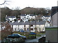
6
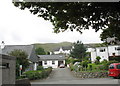
New Houses on the Upper Periphery of Llanberis
Small bungalow estates have been built in recent years on the upper periphery of the village. The mountain in the background is Moel Eilio.
Image: © Eric Jones
Taken: 30 Aug 2006
0.09 miles
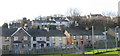
7
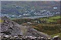
The former slate quarrying village of Llanberis viewed from Dinorwig Quarry
Llanberis, now dependent mainly on tourism, was the largest of the slate quarrying dormitory villages of the central section of the Caernarvonshire Slate Belt. Slate was practically a monolith employer between the 1830s and 1930s, with Dinorwig Quarry at the zenith of its prosperity in the 1890s employing over 3000 workers.
Image: © Eric Jones
Taken: 9 Dec 2006
0.09 miles
8
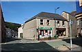
The Llanberis Tourist Information Centre, High Street
Image: © Eric Jones
Taken: 13 Jul 2008
0.10 miles
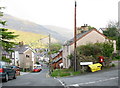
10
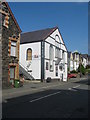
Top of Warden Street
These are typical former quarrymen's houses built at the end of the 19th C. Many have added extensions, providing bathroom and kitchen facilities. The red helicopter in the distance is the North Wales Air Ambulance.
Image: © Eric Jones
Taken: 14 Jan 2007
0.10 miles