IMAGES TAKEN NEAR TO
Waunfawr, CAERNARFON, LL55 4EJ
Introduction
This page details the photographs taken nearby to LL55 4EJ by members of the Geograph project.
The Geograph project started in 2005 with the aim of publishing, organising and preserving representative images for every square kilometre of Great Britain, Ireland and the Isle of Man.

There are currently over 7.5m images from over14,400 individuals and you can help contribute to the project by visiting https://www.geograph.org.uk
Image Map (Loading...)


Getting Data...Please wait
Leaflet Map data © OpenStreetMap
Images are licensed for reuse under creativecommons.org/licenses/by-sa/2.0
Notes
- Clicking on the map will re-center to the selected point.
- The higher the marker number, the further away the image location is from the centre of the postcode.
Image Listing (4 Images Found)
Images are licensed for reuse under creativecommons.org/licenses/by-sa/2.0
Image
Details
Distance
1
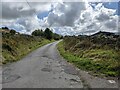
A much-repaired surface on the road to the quarries
Image: © David Medcalf
Taken: 25 Aug 2022
0.12 miles
2
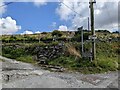
The lane to a host of holiday cottages
Five different cottages are indicated, with various styles of notice. And it's a public footpath too, at least at the start.
Image: © David Medcalf
Taken: 25 Aug 2022
0.15 miles
3
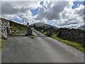
A cattle grid on the lane to the quarries
Image: © David Medcalf
Taken: 25 Aug 2022
0.22 miles
4
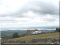
Left High and Dry
A yacht at the back of an old barn at 300m above sea level on a moorland intake at Cefn Du moors. The Menai Straits and Caernarfon Bay lie 5 kms of narrow twisty roads to the north-west
Image: © Eric Jones
Taken: 11 Aug 2006
0.24 miles