IMAGES TAKEN NEAR TO
Llanberis, CAERNARFON, LL55 4EH
Introduction
This page details the photographs taken nearby to LL55 4EH by members of the Geograph project.
The Geograph project started in 2005 with the aim of publishing, organising and preserving representative images for every square kilometre of Great Britain, Ireland and the Isle of Man.

There are currently over 7.5m images from over14,400 individuals and you can help contribute to the project by visiting https://www.geograph.org.uk
Image Map
Images are licensed for reuse under creativecommons.org/licenses/by-sa/2.0
Notes
- Clicking on the map will re-center to the selected point.
- The higher the marker number, the further away the image location is from the centre of the postcode.
Image Listing (68 Images Found)
Images are licensed for reuse under creativecommons.org/licenses/by-sa/2.0
Image
Details
Distance
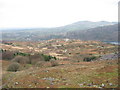
1
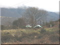
Level with the colourful yurts
These yurts at Hafotty-isaf have survived intact the near-hurricane force winds of recent months.
Image
Image: © Eric Jones
Taken: 27 Jan 2007
0.07 miles
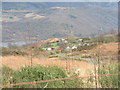
2
Colourful yurts below the Cook and Ddol Quarries
These are the temporary home of a family who are renovating an old property.
Image: © Eric Jones
Taken: 25 Jan 2007
0.08 miles
3

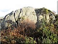
Huge ice-deposited boulders alongside the Clegyr road
Image: © Eric Jones
Taken: 8 Jul 2007
0.08 miles
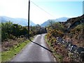
5
The Clegyr road from Cefn Du Quarry
This road, which links Llanberis and Llanrug, considerably predates the A 4086 which runs along the shores of Llyn Padarn.
Image: © Eric Jones
Taken: 26 Dec 2006
0.10 miles
6
Private road linking Clegyr with the Clegyr road
Image: © Eric Jones
Taken: 27 Jan 2007
0.10 miles
7
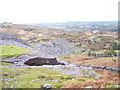
The portal and service road of the Cook&Ddol Quarries
Prior to the construction of the steam mill and the causeway connection to the Ffridd Incline c1890, finished slate from Cook&Ddol Quarries was carted to Caernarfon starting along this stretch of road. The portal is sited at the eastern end of the old reduction level.
Image: © Eric Jones
Taken: 27 Jan 2007
0.10 miles
8
An abandoned roadside cottage by Ty Newydd
Image: © Eric Jones
Taken: 14 Jan 2007
0.11 miles
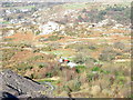
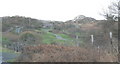
9
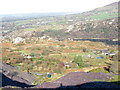
Capel Clegir - a converted chapel below the Cook&Ddol Quarry
The former Capel Clegir is the building in the centre foreground of the picture. This was a Calvinistic Methodist Chapel, its membership swollen for week night services during periods of religiosity by quarrymen from the barracks. It has long been converted into a house. The communion vessels of the old chapel are on display in the National Library of Wales at Aberystwyth.
Image: © Eric Jones
Taken: 25 Jan 2007
0.11 miles