IMAGES TAKEN NEAR TO
Cwm-y-Glo, CAERNARFON, LL55 4DU
Introduction
This page details the photographs taken nearby to LL55 4DU by members of the Geograph project.
The Geograph project started in 2005 with the aim of publishing, organising and preserving representative images for every square kilometre of Great Britain, Ireland and the Isle of Man.

There are currently over 7.5m images from over14,400 individuals and you can help contribute to the project by visiting https://www.geograph.org.uk
Image Map
Images are licensed for reuse under creativecommons.org/licenses/by-sa/2.0
Notes
- Clicking on the map will re-center to the selected point.
- The higher the marker number, the further away the image location is from the centre of the postcode.
Image Listing (30 Images Found)
Images are licensed for reuse under creativecommons.org/licenses/by-sa/2.0
Image
Details
Distance
1
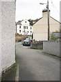
Tan-y-ffordd Terrace
These houses are built on the steep slope below the level of the road.
Image: © Eric Jones
Taken: 25 Jan 2007
0.04 miles
2
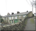
Rhes Tan-y-ffynnon Terrace
Tan-y-ffynnon (meaning 'below the well') is the street below Rhes Uwchlaw'r Ffynnon (above the well terrace) a part of which can be seen on the extreme right of the photo. The well, which gave both terraces their name, has long since been replaced by mains water supplied by Dwr Cymru/Welsh Water.
Image
Image: © Eric Jones
Taken: 27 Jan 2007
0.08 miles
3
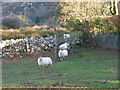
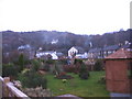
Sheep at Bwlch above the village of Cwm-y-glo
Image: © Eric Jones
Taken: 25 Jan 2007
0.09 miles
4
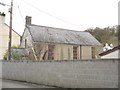
Lane leading from the main village street to the disused Barachiah Chapel
Image: © Eric Jones
Taken: 23 Mar 2008
0.10 miles
5
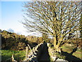
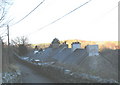
Footpath between Bwlch and Uwchlaw'r Ffynnon
Image: © Eric Jones
Taken: 25 Jan 2007
0.10 miles
6

Rhes Uwchlaw'r Ffynnon Terrace
'Uwchlaw'r Ffynnon' (meaning : 'above the well') is the highest street in Cwm-y-glo.
Image: © Eric Jones
Taken: 27 Jan 2007
0.11 miles
7
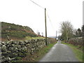
Bwlch Carreg-y-Fran Col
This col lies between Carreg-y-Fran (raven's rock) on the left and Bryn Bras (prosperous hill) on the right, and is utilised by the minor road between Llanrug and Cwm-y-glo.
Image: © Eric Jones
Taken: 27 Jan 2007
0.12 miles
8
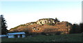
Caer Carreg-y-Fran
An minor Iron Age fort captured in the late afternoon sunlight. The meaning of Caer Carreg-y-Fran is 'raven's rock fort'.
Image: © Eric Jones
Taken: 25 Jan 2007
0.12 miles
9
Cwm y Glo early on Christmas Day, 2006
Rising smoke from the chimneys gives a clue to the early risers.
Image: © Eric Jones
Taken: 25 Dec 2006
0.14 miles