IMAGES TAKEN NEAR TO
Waunfawr, CAERNARFON, LL55 4BX
Introduction
This page details the photographs taken nearby to LL55 4BX by members of the Geograph project.
The Geograph project started in 2005 with the aim of publishing, organising and preserving representative images for every square kilometre of Great Britain, Ireland and the Isle of Man.

There are currently over 7.5m images from over14,400 individuals and you can help contribute to the project by visiting https://www.geograph.org.uk
Image Map (Loading...)


Getting Data...Please wait
Leaflet Map data © OpenStreetMap
Images are licensed for reuse under creativecommons.org/licenses/by-sa/2.0
Notes
- Clicking on the map will re-center to the selected point.
- The higher the marker number, the further away the image location is from the centre of the postcode.
Image Listing (6 Images Found)
Images are licensed for reuse under creativecommons.org/licenses/by-sa/2.0
Image
Details
Distance
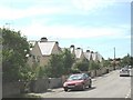
1
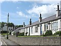
Bungalow units on the Tref Eilian estate
Image: © Eric Jones
Taken: 3 Jun 2008
0.20 miles
3
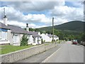
Tref Eilian Sheltered Housing Estate
Tref Eilian means "Eilian's town". The mountain in the background, marked on the OS map as Moel Eilio, is called locally Moel Eilian.
Image: © Eric Jones
Taken: 3 Jun 2008
0.20 miles
4
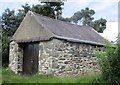
Cwt hers cymunedol / Community hearse shed
The shed still accommodated a horse-drawn hearse in the 1970s, though I doubt that it had been used for many years.
Image: © Ceri Thomas
Taken: 19 Jul 2020
0.21 miles
5
Local authority built houses at Ddol Erddi
Image: © Eric Jones
Taken: 3 Jun 2008
0.23 miles
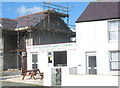
6
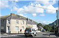
Former Shop at Minor Road Junction in Waunfawr
Image: © Eric Jones
Taken: 24 Aug 2006
0.24 miles