IMAGES TAKEN NEAR TO
Penisarwaun, CAERNARFON, LL55 3PW
Introduction
This page details the photographs taken nearby to LL55 3PW by members of the Geograph project.
The Geograph project started in 2005 with the aim of publishing, organising and preserving representative images for every square kilometre of Great Britain, Ireland and the Isle of Man.

There are currently over 7.5m images from over14,400 individuals and you can help contribute to the project by visiting https://www.geograph.org.uk
Image Map (Loading...)


Getting Data...Please wait
Leaflet Map data © OpenStreetMap
Images are licensed for reuse under creativecommons.org/licenses/by-sa/2.0
Notes
- Clicking on the map will re-center to the selected point.
- The higher the marker number, the further away the image location is from the centre of the postcode.
Image Listing (26 Images Found)
Images are licensed for reuse under creativecommons.org/licenses/by-sa/2.0
Image
Details
Distance
1
Cefn-ffordd - a much extended traditional cottage
Image: © Eric Jones
Taken: 2 Jan 2007
0.02 miles
2
Former quarryman's cottage on the outskirts of Penisarwaen
The vast Dinorwig Quarry can be seen in the background. It was like 'a city set on a hill' visible to every quarryman even on his rest days.
Image: © Eric Jones
Taken: 2 Jan 2007
0.07 miles
3
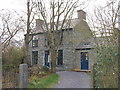
Gorffwysfa, Waen
A solidly built Victorian house. Gorffwysfa means 'place of rest'.
Image: © Eric Jones
Taken: 2 Jan 2007
0.07 miles
4
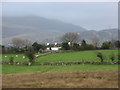
Rough grazing at Fferm Gors Farm
This land, wrested from the bog, provides poor waterlogged pasturage most of the year. The hill in the background is Moel-y-Ci.
Image: © Eric Jones
Taken: 2 Jan 2007
0.07 miles
5
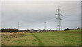
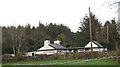
Pylons and conifer forests - the twentieth century 's contribution to the landscape
This picture is taken from the public footpath linking Waen with the main Deiniolen-Caernarfon road.
Image: © Eric Jones
Taken: 2 Jan 2007
0.07 miles
6
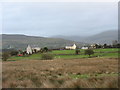
Bryn Arthur and Rhos-wian - dry site settlements on the edge of the Waen
Image: © Eric Jones
Taken: 2 Jan 2007
0.07 miles
7

Ty Newydd and Cerrig Gwynion
Ty Newydd (new house) and Cerrig Gwynion (white stones) were two early nineteenth century enclosed small holdings. Both have been extensively modernised in recent years.
Image: © Eric Jones
Taken: 2 Jan 2007
0.07 miles
9
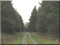
The road to Gors Farm
Cors (here mutated to Gors) simply means a bog, a fen or a swamp.
Image: © Eric Jones
Taken: 2 Jan 2007
0.07 miles
10
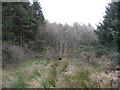
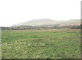
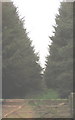
A combination of bog and forest
In earlier centuries this 'waen' was treated with a degree of circumspection being avoided alike by settlement and lines of communication. It was only in the nineteenth century with the great increase in population in the wake of growth of the slate industry that its edges were enclosed to create farms and small-holdings. But even then, no through road was built across the Waen.
Image: © Eric Jones
Taken: 2 Jan 2007
0.07 miles