IMAGES TAKEN NEAR TO
Green Terrace, CAERNARFON, LL55 3LE
Introduction
This page details the photographs taken nearby to Green Terrace, LL55 3LE by members of the Geograph project.
The Geograph project started in 2005 with the aim of publishing, organising and preserving representative images for every square kilometre of Great Britain, Ireland and the Isle of Man.

There are currently over 7.5m images from over14,400 individuals and you can help contribute to the project by visiting https://www.geograph.org.uk
Image Map (Loading...)


Getting Data...Please wait
Leaflet Map data © OpenStreetMap
Images are licensed for reuse under creativecommons.org/licenses/by-sa/2.0
Notes
- Clicking on the map will re-center to the selected point.
- The higher the marker number, the further away the image location is from the centre of the postcode.
Image Listing (80 Images Found)
Images are licensed for reuse under creativecommons.org/licenses/by-sa/2.0
Image
Details
Distance
2
Tai Gweledfa, Deiniolen
Quarrymen's cottages in Llanddeiniolen
Image: © Eirian Evans
Taken: 23 Apr 2008
0.03 miles
3
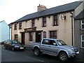
Y Bwl - The Bull Inn, Deiniolen
This is the last surviving public house in the Deiniolen area.
Image: © Eric Jones
Taken: 23 Jan 2011
0.03 miles
4
The Bull Inn
One of only two public houses in the area to survive the 1904-05 Religious Revival. It, like the Wellington Inn Image, is situated in the centre of the village. In the 1950s, Friday evenings, and especially the 'Fridays of the Great Pay Count' (Gwener Cyfrif Mawr) when the quarrymen received their monthly bonus, used to be the evenings of heavy drinking. Even then, the pubs closed at 9 p.m. Before they took to religion, a trend enthusiastically endorsed by the quarry owners, it was not uncommon for slate quarrymen - including my great-grandfather - to go on 'spree' lasting a full week following the bonus paying day.
Image: © Eric Jones
Taken: 21 Sep 2006
0.03 miles
5
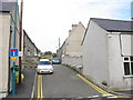
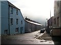
Porth Gogladd - North Road
A side street leading north from the High Street. The entrance used to be much narrower, but was widened by demolishing the end house on the left. A track at the end of the lane leads on to the moor.
Image: © Eric Jones
Taken: 21 Sep 2006
0.03 miles
6
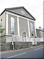
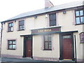
Capel Ebenezer Chapel
'Capal Eban', as it is known locally, is a Welsh Independent Chapel. It was built initially in 1823 at a time when, under the stimulus of the development of the Dinorwig Slate Quarry, the village of Deiniolen was growing rapidly. Indeed, until 1923, when the name Deiniolen was adopted, the village was officially called Ebenezer.
Image
Image: © Eric Jones
Taken: 21 Sep 2006
0.03 miles
7
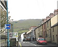
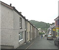
The Lower End of Y Stryd Fawr (High Street) , Deiniolen
The chapel on the left is Ebenezer Independent Chapel. Until the 1920s, the village was known as Ebenezer. The mountains in the background are Elidir Fach and, peeping above it, Elidir Fawr.
Image: © Eric Jones
Taken: 24 May 2006
0.03 miles
8
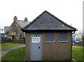
Ar Werth/For Sale Deiniolen's Public Toilets
Thanks to Dave's salami slicing tactics the cash strapped Gwynedd Council has decided to put many of its village public toilets on sale. This at Deiniolen is one of them. The village's war time air raid shelter previously stood on this spot.
Image: © Eric Jones
Taken: 23 Jan 2011
0.03 miles
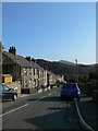
9
The top of Deiniol Road
This road links Deiniolen with Clwt-y-Bont, once two separate villages.
Image: © Eric Jones
Taken: 23 Jan 2011
0.04 miles
10
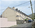
Caradog Place
A terrace of fine Victorian built workers' houses.
Image: © Eric Jones
Taken: 21 Sep 2006
0.04 miles