IMAGES TAKEN NEAR TO
Dinorwic, CAERNARFON, LL55 3ER
Introduction
This page details the photographs taken nearby to LL55 3ER by members of the Geograph project.
The Geograph project started in 2005 with the aim of publishing, organising and preserving representative images for every square kilometre of Great Britain, Ireland and the Isle of Man.

There are currently over 7.5m images from over14,400 individuals and you can help contribute to the project by visiting https://www.geograph.org.uk
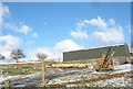
Image Map
Images are licensed for reuse under creativecommons.org/licenses/by-sa/2.0
Notes
- Clicking on the map will re-center to the selected point.
- The higher the marker number, the further away the image location is from the centre of the postcode.
Image Listing (33 Images Found)
Images are licensed for reuse under creativecommons.org/licenses/by-sa/2.0
Image
Details
Distance
1
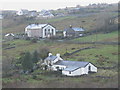
Dinorwig
This photograph shows part of the former slate quarrying village of Dinorwig. Since the closure of the quarry, many of the houses have been purchased by outsiders, some for use as holiday homes, and most have undergone a programme of renovation. The house in the foreground is Ty Newydd. Two of the three places of worship, Capel Dinorwig (Calv.Meth.) (middleground), and Y Santes Fair (Church in Wales), (background, left) have been converted into dwellings. Sardis, Wales' highest chapel, (skyline, right), is still used for services.
Image: © Eric Jones
Taken: 16 Dec 2006
0.05 miles
3
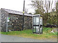
Telephone box
Telephone box Dinorwig Gwynedd.
Image: © Keith Evans
Taken: 29 Oct 2008
0.09 miles
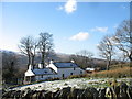
5
Sheep gathered into the yard of Fferm Bryn Eilian
Image: © Eric Jones
Taken: 22 Jan 2007
0.14 miles
6
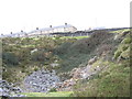
Chwarel Fawr Quarry
This is one of the oldest quarries in the district. Its mill dates back to the 1830s. In later times it was worked in tandem with Allt Ddu Quarry. Up to the 1960s Chwarel Fawr was a deep flooded pit next to the main road which had been diverted to go round it. In the 1980s the whole site was landscaped with the waste tips being fed into the pit and the diverted main road, now straightened, runs across where the pit used to be.
Image: © Eric Jones
Taken: 22 Jan 2007
0.14 miles
7
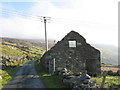
Ruined barn once belonging to Tan-y-Braich
This barn is situated on the opposite side of Lon Garret. The electricity transmission lines crossing the photograph lead to both the upper part of the Dinorwig HEP station and the Penrhyn Quarry, Bethesda.
Image
Image: © Eric Jones
Taken: 23 Dec 2006
0.15 miles
8
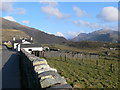
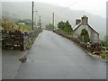
Approaching Dinorwig
Dinorwig is known as slate-quarrying area though the Dinorwig Quarry closed in 1969, after nearly 200 years production. The jagged mountain in the centre is Crib Goch, part of the Snowdon massif.
Image: © Eirian Evans
Taken: 23 Apr 2008
0.15 miles
9
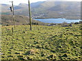
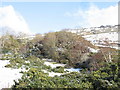
View to Llyn Padarn from Gallt-y-Foel
The town over the other side of the lake is Llanberis
Image: © Eirian Evans
Taken: 23 Apr 2008
0.15 miles
10
Lower workings of Chwarel Lloc Quarry
A 'lloc' is a pinfold. This is a very old quarry, the site of which has been divided by the modern road. The houses above is the council's Maes Eilian estate.
Image: © Eric Jones
Taken: 20 Jan 2007
0.15 miles