IMAGES TAKEN NEAR TO
Llanddeiniolen, CAERNARFON, LL55 3AD
Introduction
This page details the photographs taken nearby to LL55 3AD by members of the Geograph project.
The Geograph project started in 2005 with the aim of publishing, organising and preserving representative images for every square kilometre of Great Britain, Ireland and the Isle of Man.

There are currently over 7.5m images from over14,400 individuals and you can help contribute to the project by visiting https://www.geograph.org.uk
Image Map
Images are licensed for reuse under creativecommons.org/licenses/by-sa/2.0
Notes
- Clicking on the map will re-center to the selected point.
- The higher the marker number, the further away the image location is from the centre of the postcode.
Image Listing (18 Images Found)
Images are licensed for reuse under creativecommons.org/licenses/by-sa/2.0
Image
Details
Distance
1
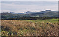
Wetland at Llanddeiniolen
The Carneddau form the background.
Image: © Eric Jones
Taken: 4 Oct 2000
0.07 miles
2
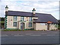
Gors Bach Inn, Llanddeiniolen
Situated on B4366 in the small hamlet of Llanddeiniolen.
Another victim of the decline in Public Houses.
See just over two years earlier: Image
Image: © Carl Farnell
Taken: 4 Sep 2010
0.12 miles
3
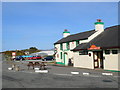
Gors Bach, Llanddeiniolen
On the B4366 in the hamlet of Llanddeiniolen, with magnificent views southward towards Snowdonia.
Image: © Eirian Evans
Taken: 23 Apr 2008
0.12 miles
4
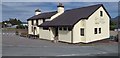
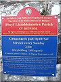
Gors Bach, Llanddeiniolen
Gors Bach public house, Llanddeiniolen, shut due to the current corona 19 virus.
Image: © Colin Kinnear
Taken: 30 Jul 2020
0.13 miles
5
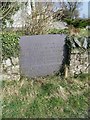
A slate commemorative stone outside the grounds of the former school, Llanddeiniolen
This slate commemorative stone is located in the boundary wall of the former school.
Image: © Meirion
Taken: 24 Mar 2011
0.13 miles
6
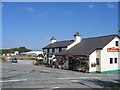
Gors Bach, Llanddeiniolen
This public house, marked on the OS Map, is a prominent landmark at this road junction on the Caernarfon Road.
Image: © David Stowell
Taken: 17 Aug 2005
0.15 miles
10
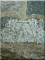
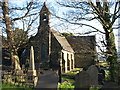
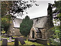
Benchmark on St. Deiniolen's Church, Llanddeiniolen
This benchmark is located on the SE face of St. Deniniolen's church (Eglwys Llanddeiniolen) in Llanddeniolen & it is shown in the current Ordnance Survey database at a height of 126.1903m above the Newlyn datum.
Image: © Meirion
Taken: 24 Mar 2011
0.19 miles