IMAGES TAKEN NEAR TO
Caeathro, CAERNARFON, LL55 2SL
Introduction
This page details the photographs taken nearby to LL55 2SL by members of the Geograph project.
The Geograph project started in 2005 with the aim of publishing, organising and preserving representative images for every square kilometre of Great Britain, Ireland and the Isle of Man.

There are currently over 7.5m images from over14,400 individuals and you can help contribute to the project by visiting https://www.geograph.org.uk
Image Map
Images are licensed for reuse under creativecommons.org/licenses/by-sa/2.0
Notes
- Clicking on the map will re-center to the selected point.
- The higher the marker number, the further away the image location is from the centre of the postcode.
Image Listing (7 Images Found)
Images are licensed for reuse under creativecommons.org/licenses/by-sa/2.0
Image
Details
Distance
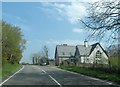
2
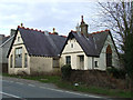
Derelict Building near to Caeathro
A derelict building alongside the road on the outskirts of Caeathro
Image: © Nigel Williams
Taken: 16 Apr 2006
0.06 miles
3
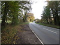
The road between Caeathro and Pont Rug
Image: © Eirian Evans
Taken: 16 Nov 2013
0.15 miles
4
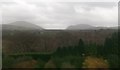
Woodland in the lower Seiont Valley
Moel Eilio and Mynydd Mawr (Elephant Mountain) form the background.
Image: © Eric Jones
Taken: 25 Nov 2009
0.18 miles
5
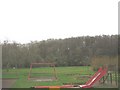
A children's playground within a meander bend
The river cliff on the opposite side of the incised meander is wooded.
Image: © Eric Jones
Taken: 23 Dec 2008
0.21 miles
6
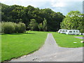
The caravan site at Seiont Garden Centre
Nestled in a crook of the Afon Seiont.
Image: © David Medcalf
Taken: 27 Sep 2007
0.23 miles
7
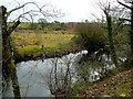
Afon Seiont
Looking east across the river from the Seiont Garden Centre car park.
Image: © Jonathan Billinger
Taken: 26 Feb 2009
0.25 miles