IMAGES TAKEN NEAR TO
Llys Tryfan, CAERNARFON, LL55 2LS
Introduction
This page details the photographs taken nearby to Llys Tryfan, LL55 2LS by members of the Geograph project.
The Geograph project started in 2005 with the aim of publishing, organising and preserving representative images for every square kilometre of Great Britain, Ireland and the Isle of Man.

There are currently over 7.5m images from over14,400 individuals and you can help contribute to the project by visiting https://www.geograph.org.uk
Image Map (165 Images)


Getting Data...Please wait
Leaflet Map data © OpenStreetMap
Images are licensed for reuse under creativecommons.org/licenses/by-sa/2.0
Notes
- Clicking on the map will re-center to the selected point.
- The higher the marker number, the further away the image location is from the centre of the postcode.
Image Listing (165 Images Found)
Images are licensed for reuse under creativecommons.org/licenses/by-sa/2.0
Image
Details
Distance
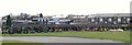
1
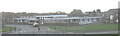
Ysgol yr Hendre Primary School
This school has a catchment area which includes the Hendre Estate of private housing and the large local authority estates between the Llanbeblig and Llanberis roads.
Image: © Eric Jones
Taken: 26 Oct 2006
0.04 miles
2
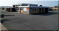
Ysgol yr Hendre, Caernarfon
This is the north side of the primary school, viewed from Ffordd Eryri.
Image: © Jaggery
Taken: 25 Mar 2012
0.04 miles
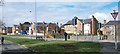
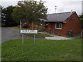
3
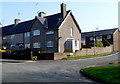
Corner of Llys Tryfan and Ffordd Eryri, Caernarfon
Llys Tryfan is on the right.
Image: © Jaggery
Taken: 25 Mar 2012
0.05 miles
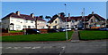
4
Houses arranged around a green in Cefn Hendre
Image: © Eric Jones
Taken: 3 Apr 2010
0.07 miles
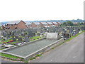
5
Decorated graves in the new section of Llanbeblig Cemetery
In the rural areas of Wales flowers are placed on graves for Palm Sunday. The Welsh name for Palm Sunday is "Sul y Blodau" [Flower Sunday]. The flat roofed building behind is Ysgol yr Hendre - a primary school.
Image: © Eric Jones
Taken: 3 Apr 2008
0.07 miles
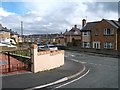
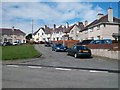
6
Cefn Hendre houses, Caernarfon
Part of a triangular arrangement of houses on the north side of Ffordd Eryri.
Image: © Jaggery
Taken: 25 Mar 2012
0.07 miles
7
Caernarfon: Bungalo?s Bungalows
This little row of bungalows, named Llys y Foel on the sign, has a curious English version given below in smaller lettering.
Image: © Chris Downer
Taken: 14 Aug 2013
0.08 miles
8
Grave of the Victims of the Aer Lingus Crash of 1952
This is the grave of the 12 recovered bodies of the 23 people killed on 10th January, 1952 when the Aer Lingus Douglas DC-3 Dakota 'St Kevin' enroute from Northolt to Dublin clipped Snowdon and crashed into a peat bog in Cwm Edno Image The victims are buried in the north-east corner of the new cemetery across the road from Llanbeblig Church.
Image
Image: © Eric Jones
Taken: 17 Aug 2006
0.08 miles