IMAGES TAKEN NEAR TO
St. Helens Street, CAERNARFON, LL55 2HU
Introduction
This page details the photographs taken nearby to St. Helens Street, LL55 2HU by members of the Geograph project.
The Geograph project started in 2005 with the aim of publishing, organising and preserving representative images for every square kilometre of Great Britain, Ireland and the Isle of Man.

There are currently over 7.5m images from over14,400 individuals and you can help contribute to the project by visiting https://www.geograph.org.uk
Image Map (Loading...)


Getting Data...Please wait
Leaflet Map data © OpenStreetMap
Images are licensed for reuse under creativecommons.org/licenses/by-sa/2.0
Notes
- Clicking on the map will re-center to the selected point.
- The higher the marker number, the further away the image location is from the centre of the postcode.
Image Listing (366 Images Found)
Images are licensed for reuse under creativecommons.org/licenses/by-sa/2.0
Image
Details
Distance
1
Henwaliau
Henwaliau means "ancient walls". This was the site of a small Roman fortress which guarded the Seiont estuary against incursions by Irish pirates.
Image: © Eric Jones
Taken: 3 Apr 2010
0.02 miles
2
Hen Waliau - Roman Walls
Hen Waliau (Old Walls). Part of a Roman fortlet built overlooking the estuary of the Seiont in the 3rd century as a bulwark against Irish incursions. http://www.roman-britain.org/places/segontium.htm
Image: © Eric Jones
Taken: 19 Oct 2006
0.02 miles
3
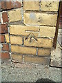
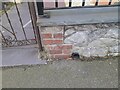
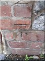
Benchmark at 33 Marcus Street, Caernarfon
This benchmark is located on the garden wall of No. 33 Marcus Street in Caernarfon and it is shown in the current Ordnance Survey database at a height of 30.54m above the Newlyn datum.
Image: © Meirion
Taken: 20 Jul 2011
0.03 miles
4
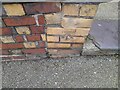
Ordnance Survey Cut Mark
This OS cut mark can be found on the wall of No33 Marcus Street. It marks a point 30.540m above mean sea level.
Image: © Adrian Dust
Taken: 24 Jan 2023
0.03 miles
5
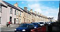
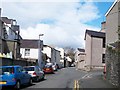
Stryd Marcws
Stryd Marcws runs northwards from Henwaliau (the site of a Roman fortlet). Stryd Marcws is named after Marcus Aurelius.
Image: © Eric Jones
Taken: 3 Apr 2010
0.04 miles
6
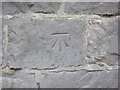
Ordnance Survey Cut Mark
This OS cut mark can be found on the wall of No12 Segontium Road South. It marks a point 128.1ft above mean sea level.
Image: © Adrian Dust
Taken: 24 Jan 2023
0.06 miles
8
Benchmark on L?n Parc, Caernarfon
This benchmark is located on the E side of Lôn Parc (South Road) in Caernarfon & it is shown in the current Ordnance Survey database at a height of 21.0101m above the Newlyn datum.
Image: © Meirion
Taken: 20 Jul 2011
0.06 miles
9
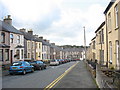
Benchmark on Ffordd Segontiwm, Caernarfon
This benchmark is located on Ffordd Segontiwm (Segontium Road South) in Caernarfon. The mark is not shown in the current Ordnance Survey database but is shown on an 1888 map of the area as being 128.1ft above the Liverpool datum.
Image: © Meirion
Taken: 6 Sep 2010
0.06 miles
10
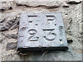
Old F.P. (Fire Point) marker on South Road, Caernarfon
Image: © Meirion
Taken: 6 Dec 2019
0.06 miles