IMAGES TAKEN NEAR TO
Cibyn Industrial Estate, CAERNARFON, LL55 2BF
Introduction
This page details the photographs taken nearby to Cibyn Industrial Estate, LL55 2BF by members of the Geograph project.
The Geograph project started in 2005 with the aim of publishing, organising and preserving representative images for every square kilometre of Great Britain, Ireland and the Isle of Man.

There are currently over 7.5m images from over14,400 individuals and you can help contribute to the project by visiting https://www.geograph.org.uk
Image Map
Images are licensed for reuse under creativecommons.org/licenses/by-sa/2.0
Notes
- Clicking on the map will re-center to the selected point.
- The higher the marker number, the further away the image location is from the centre of the postcode.
Image Listing (10 Images Found)
Images are licensed for reuse under creativecommons.org/licenses/by-sa/2.0
Image
Details
Distance
1
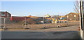
Construction site east of Lon Ty Newydd, Cibyn Industrial Estate
This site is at the back of the Gwynedd Skip Service.
Image: © Eric Jones
Taken: 3 Jan 2008
0.08 miles
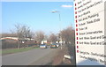
2
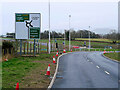
Llanberis Road approaching Bypass
Remnants of the roadworks at the new roundabout where the A4086 meets the "new" A487 Caernarfon to Bontnewydd bypass https://gov.wales/a487-caernarfon-bontnewydd-bypass which was due to be opened later in the week.
Image: © David Dixon
Taken: 15 Feb 2022
0.11 miles
3
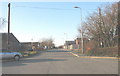
Lon Hen Felin
Lon Hen Felin (=old mill lane) is one of the main link roads on the Cibyn Industrial Estate.
Image: © Eric Jones
Taken: 3 Jan 2008
0.13 miles
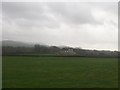
6
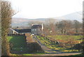
Bodrual
This is a former farmhouse east of the Cibyn Industrial Estate.
Image: © Eric Jones
Taken: 3 Jan 2008
0.15 miles
7
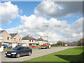
The eastern edge of Caernarfon
These houses on the Llanberis road are most easterly houses within the town.
Image: © Eric Jones
Taken: 20 Mar 2007
0.19 miles
8
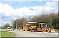
The junction of the Cibyn Estate road and the A4086 Llanberis road
Image: © Eric Jones
Taken: 20 Mar 2007
0.20 miles
9
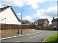
Stad Llain y Felin
Stad Llain y Felin (mill patch estate) was built in the late 1990s
Image: © Eric Jones
Taken: 20 Mar 2007
0.24 miles
10
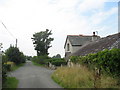
Cae Garw
A small holding with a number of horses in its fields. The house stands on a mile-long straight road at the end of which is an earthworks, believed to be the remains of a Roman signalling station. It is very possible, therefore, that the road is Roman in origin.
Image: © Eric Jones
Taken: 17 Aug 2006
0.25 miles