IMAGES TAKEN NEAR TO
Bethel, CAERNARFON, LL55 1YD
Introduction
This page details the photographs taken nearby to LL55 1YD by members of the Geograph project.
The Geograph project started in 2005 with the aim of publishing, organising and preserving representative images for every square kilometre of Great Britain, Ireland and the Isle of Man.

There are currently over 7.5m images from over14,400 individuals and you can help contribute to the project by visiting https://www.geograph.org.uk
Image Map (Loading...)


Getting Data...Please wait
Leaflet Map data © OpenStreetMap
Images are licensed for reuse under creativecommons.org/licenses/by-sa/2.0
Notes
- Clicking on the map will re-center to the selected point.
- The higher the marker number, the further away the image location is from the centre of the postcode.
Image Listing (7 Images Found)
Images are licensed for reuse under creativecommons.org/licenses/by-sa/2.0
Image
Details
Distance
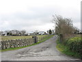
2
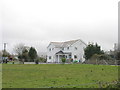
Large, modern, house on the NE outskirts of Bethel
Image: © Eric Jones
Taken: 10 Mar 2007
0.11 miles
3
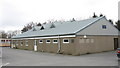
Neuadd Goffa Bethel Memorial Hall
This village hall and community centre was built as a memorial to the men and women of the Bethel area lost in two World Wars.
Image: © Eric Jones
Taken: 10 Mar 2007
0.17 miles
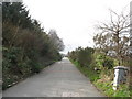
4
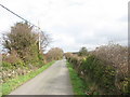
Approaching the entrance to Wern Farm (left) and Cefn Isaf Farm (right)
Image: © Eric Jones
Taken: 10 Mar 2007
0.21 miles
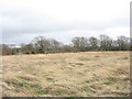
6

View north-west across a boggy river valley
This stream, unnamed on the map rises near Seion (SH5467) and discharges into the Menai Strait near the former Dynamex factory in square SH4965.
Image: © Eric Jones
Taken: 10 Mar 2007
0.23 miles