IMAGES TAKEN NEAR TO
Bethel, CAERNARFON, LL55 1UR
Introduction
This page details the photographs taken nearby to LL55 1UR by members of the Geograph project.
The Geograph project started in 2005 with the aim of publishing, organising and preserving representative images for every square kilometre of Great Britain, Ireland and the Isle of Man.

There are currently over 7.5m images from over14,400 individuals and you can help contribute to the project by visiting https://www.geograph.org.uk
Image Map (Loading...)


Getting Data...Please wait
Leaflet Map data © OpenStreetMap
Images are licensed for reuse under creativecommons.org/licenses/by-sa/2.0
Notes
- Clicking on the map will re-center to the selected point.
- The higher the marker number, the further away the image location is from the centre of the postcode.
Image Listing (18 Images Found)
Images are licensed for reuse under creativecommons.org/licenses/by-sa/2.0
Image
Details
Distance
1
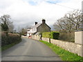
Victorian houses on the western outskirts of Bethel
Image: © Eric Jones
Taken: 24 Mar 2008
0.02 miles
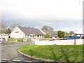
2
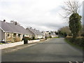
Semi-detached bungalows on the Tan-y-Buarth estate
Image: © Eric Jones
Taken: 24 Mar 2008
0.02 miles
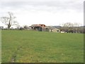
3
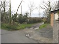
Ford and footbridge at the entrance to Greuor Farm
Image: © Eric Jones
Taken: 24 Mar 2008
0.04 miles
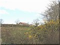
7
Tan-y-buarth - an estate of modern bungalows
Image: © Eric Jones
Taken: 24 Mar 2008
0.09 miles
8
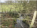
Afon Cadnant
A pipeline can be seen crossing the stream.
Image: © Eric Jones
Taken: 24 Mar 2008
0.10 miles
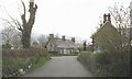
10
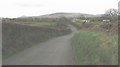
View back towards Bethel along the country road
Image: © Eric Jones
Taken: 24 Mar 2008
0.15 miles