IMAGES TAKEN NEAR TO
Crown Street, CAERNARFON, LL55 1SY
Introduction
This page details the photographs taken nearby to Crown Street, LL55 1SY by members of the Geograph project.
The Geograph project started in 2005 with the aim of publishing, organising and preserving representative images for every square kilometre of Great Britain, Ireland and the Isle of Man.

There are currently over 7.5m images from over14,400 individuals and you can help contribute to the project by visiting https://www.geograph.org.uk
Image Map (Loading...)


Getting Data...Please wait
Leaflet Map data © OpenStreetMap
Images are licensed for reuse under creativecommons.org/licenses/by-sa/2.0
Notes
- Clicking on the map will re-center to the selected point.
- The higher the marker number, the further away the image location is from the centre of the postcode.
Image Listing (1502 Images Found)
Images are licensed for reuse under creativecommons.org/licenses/by-sa/2.0
Image
Details
Distance
1
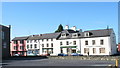
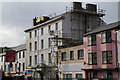
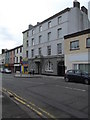
Snowdonia Windows & Doors, Caernarfon
Viewed across Crown Street. The business also has premises in Bromfield Industrial Estate, Mold, Flintshire.
Image: © Jaggery
Taken: 25 Mar 2012
0.01 miles
2
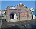
Empire, Caernarfon
The former cinema on the corner of Crown Street and Balaclava Road is now in use as a bingo hall.
Image: © Jaggery
Taken: 25 Mar 2012
0.02 miles
3
The Empire, Caernarfon
The Empire Cinema was the first purpose built cinema in Caernarfon, opened by Mr. Caradoc Rowlands in 1915.
A bingo licence was acquired in the early-1970’s and film shows were reduced to 4 nights per week. Eventually bingo took over completely and in 1986, following the death of Guy Baker, Apollo Leisure took over the hall.
Image: © Richard Hoare
Taken: 10 May 2015
0.02 miles
5
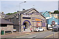
The Empire, Caernarfon
Opened in 1915, the Empire was Caernarfon's first purpose built cinema. It became a venue for both bingo and movies in the early 1970's before moving entirely to bingo. It is now owned by Apollo Leisure.
Source: Cinema Treasures
Image: © Jeff Buck
Taken: 14 Jun 2017
0.02 miles
6
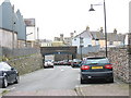
Relief road on the former BR trackway
This section of track had possibly the steepest gradient on the BR system in North Wales
Image: © Eric Jones
Taken: 21 Feb 2007
0.02 miles
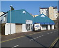
7
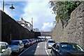
Car Park in Caernarfon
Now a car park and exit road, this was once part the trackbed of the LNWR railway line from Caernarfon to Afonwen.
Image: © Kevin Williams
Taken: 12 Apr 2012
0.03 miles
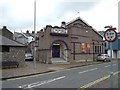
8
Old Liberal Club building, Caernarfon
No longer a hang-out for Caernarfon Liberals, but housing a firm of solicitors.
Image: © Eirian Evans
Taken: 16 Nov 2013
0.03 miles
9
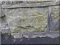
Ordnance Survey Cut Mark
This OS cut mark can be found on a post of the chapel on Bangor Street. It marks a point 11.200m above mean sea level.
Image: © Adrian Dust
Taken: 25 Jan 2023
0.03 miles