IMAGES TAKEN NEAR TO
Cae Llwybr, CAERNARFON, LL55 1PU
Introduction
This page details the photographs taken nearby to Cae Llwybr, LL55 1PU by members of the Geograph project.
The Geograph project started in 2005 with the aim of publishing, organising and preserving representative images for every square kilometre of Great Britain, Ireland and the Isle of Man.

There are currently over 7.5m images from over14,400 individuals and you can help contribute to the project by visiting https://www.geograph.org.uk
Image Map
Images are licensed for reuse under creativecommons.org/licenses/by-sa/2.0
Notes
- Clicking on the map will re-center to the selected point.
- The higher the marker number, the further away the image location is from the centre of the postcode.
Image Listing (16 Images Found)
Images are licensed for reuse under creativecommons.org/licenses/by-sa/2.0
Image
Details
Distance
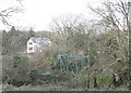
1
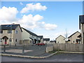
New Local Authority housing at Maesincla
Image: © Eric Jones
Taken: 20 Mar 2007
0.00 miles
2
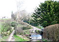
Maesincla-isaf footbridge and ford viewed from the west
Image: © Eric Jones
Taken: 20 Mar 2007
0.08 miles
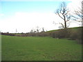
3
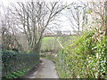
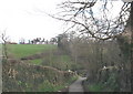
Narrow lane to Maesincla
This lane, once a driveway to Maesincla House, is now used mainly as a footpath linking the Llanberis road with Stad Maesincla, a local authority estate.
Image: © Eric Jones
Taken: 20 Mar 2007
0.09 miles
4
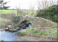
Ford and footbridge over Afon Cadnant at Maesincla isaf
Image: © Eric Jones
Taken: 20 Mar 2007
0.09 miles
6
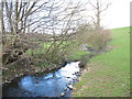
Afon Cadnant above the Maesincla-isaf footbridge
Image: © Eric Jones
Taken: 20 Mar 2007
0.10 miles
8
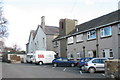
Plas Maesincla Local Authority Residential Home
Image: © Eric Jones
Taken: 20 Mar 2007
0.17 miles
10
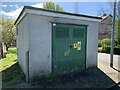
Plas Maesincla substation on Maesincla Lane, Caernarfon
See also Image
Image: © Meirion
Taken: 19 Apr 2024
0.19 miles